Earthquake MOLUCCA SEA
Wed, 29 Mar 2017 03:30:26 GMT
Time8 years ago
Location
2.8200, 126.0400
Depth
122.0 KM
Event Summary
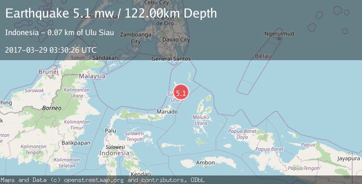
A 5.1 magnitude earthquake struck on MOLUCCA SEA, at Wed, 29 Mar 2017 03:30:26 GMT. Depth: 122km. Reviewed by EMSC seismologists, this moderate quake occurred at a magnitude type of mw.
Magnitude
5.1
mw
Source
EMSC
Intensity
-
Agency Reports
1 Sources| Source | Magnitude | Depth | Time |
|---|---|---|---|
| EMSCPrimary | 5.1 | 122 km | 8 years ago |
Earthquake Details
AutomaticEvent IDemsc_EMSC_20170329_0000011
Tsunami PotentialNo
Magnitude Typemw
Nearest Places
- Pulau Batupuntieng48.0 km
- Pulau Batukemba48.3 km
- Pulau Batuluha48.4 km
- Pulau Nenung48.6 km
- Pulau Batupaliaheng48.9 km
Comments
Join the discussion about this event.
Latest Earthquakes
2.3Mag
NEVADA
Time20 hours ago
Depth4.70 km
SourceNN (Automatic)
1.4Mag
4 km ENE of Graton, CA
Time20 hours ago
Depth6.77 km
SourceUSGS (Automatic)
2.5Mag
WESTERN TURKEY
Time20 hours ago
Depth12.00 km
SourceKOERI (Automatic)
2.2Mag
Tarapaca, Chile
Time20 hours ago
Depth10.74 km
SourceVYT (Automatic)
1.6Mag
3 km W of Cobb, CA
Time20 hours ago
Depth1.71 km
SourceUSGS (Automatic)
Nearby Earthquakes
3.5Mag
Molucca Sea
Time6 days ago
Depth114.87 km
SourceVYT (Automatic)
4.0Mag
MOLUCCA SEA
Time6 years ago
Depth102.00 km
SourceDJA (Automatic)
4.0Mag
MOLUCCA SEA
Time2 years ago
Depth94.00 km
SourceBMKG (Automatic)
3.0Mag
MOLUCCA SEA
Time3 months ago
Depth12.00 km
SourceBMKG (Automatic)
5.2Mag
KEPULAUAN SANGIHE, INDONESIA
Time16 years ago
Depth100.00 km
SourceEMSC (Automatic)