Earthquake Molucca Sea
Fri, 13 Feb 2026 15:24:00 GMT
Time6 days ago
Location
2.8259, 126.0291
Depth
114.9 KM
Event Summary
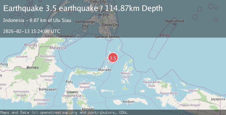
A 3.5 magnitude earthquake struck on Molucca Sea, at Fri, 13 Feb 2026 15:24:00 GMT. Depth: 114.8681640625km. Reviewed by VYT seismologists, this minor quake occurred at a magnitude type of earthquake.
Magnitude
3.5
earthquake
Source
VYT
Intensity
-
Agency Reports
1 Sources| Source | Magnitude | Depth | Time |
|---|---|---|---|
| VYTPrimary | 3.5 | 115 km | 6 days ago |
Earthquake Details
AutomaticEvent IDvyt_1buy7960bg6d6
Tsunami PotentialNo
Magnitude Typeearthquake
Nearest Places
- Pulau Batupuntieng46.6 km
- Pulau Batukemba47.0 km
- Pulau Batuluha47.0 km
- Pulau Nenung47.2 km
- Pulau Batupaliaheng47.5 km
Comments
Join the discussion about this event.
Latest Earthquakes
1.6Mag
Java, Indonesia
Time2 minutes ago
Depth0.24 km
SourceVYT (Automatic)
2.4Mag
western Texas
Time3 minutes ago
Depth22.83 km
SourceVYT (Automatic)
3.7Mag
Fox Islands, Aleutian Islands, Alaska
Time5 minutes ago
Depth11.96 km
SourceVYT (Automatic)
2.7Mag
Timor Region
Time8 minutes ago
Depth14.44 km
SourceBMKG
2.2Mag
Halmahera, Indonesia
Time10 minutes ago
Depth4.36 km
SourceBMKG
Nearby Earthquakes
5.1Mag
MOLUCCA SEA
Time8 years ago
Depth122.00 km
SourceEMSC (Automatic)
4.0Mag
MOLUCCA SEA
Time6 years ago
Depth102.00 km
SourceDJA (Automatic)
4.0Mag
MOLUCCA SEA
Time2 years ago
Depth94.00 km
SourceBMKG (Automatic)
3.0Mag
MOLUCCA SEA
Time3 months ago
Depth12.00 km
SourceBMKG (Automatic)
5.2Mag
KEPULAUAN SANGIHE, INDONESIA
Time16 years ago
Depth100.00 km
SourceEMSC (Automatic)