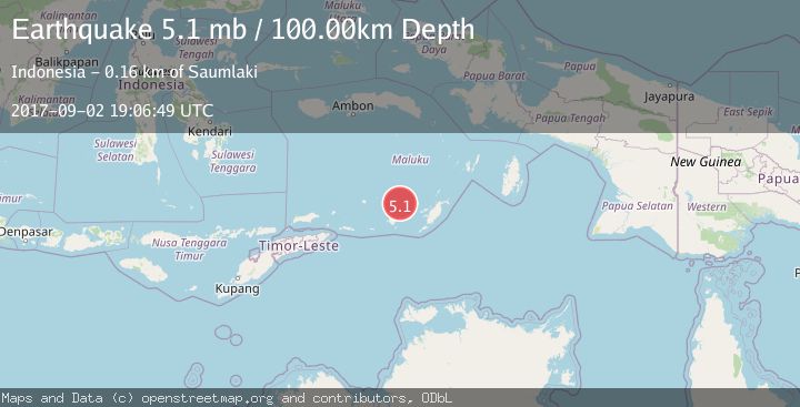
Earthquake KEP. TANIMBAR REGION, INDONESIA
Sat, 02 Sep 2017 19:06:49 GMT
Time8 years ago
Location
-7.2100, 130.0600
Depth
100.0 KM
Event Summary
A 5.1 magnitude earthquake struck on KEP. TANIMBAR REGION, INDONESIA, at Sat, 02 Sep 2017 19:06:49 GMT. Depth: 100km. Reviewed by EMSC seismologists, this moderate quake occurred at a magnitude type of mb.
Magnitude
5.1
mb
Source
EMSC
Intensity
-
Agency Reports
1 Sources| Source | Magnitude | Depth | Time |
|---|---|---|---|
| EMSCPrimary | 5.1 | 100 km | 8 years ago |
Earthquake Details
AutomaticEvent IDemsc_EMSC_20170902_0000067
Tsunami PotentialNo
Magnitude Typemb
Nearest Places
- Wakarlawen53.4 km
- Desa Lewah54.6 km
- Welora55.0 km
- Lewa55.3 km
- Ilhar55.5 km
Comments
Join the discussion about this event.
Latest Earthquakes
1.7Mag
Kenai Peninsula, Alaska
Time7 hours ago
Depth12.33 km
SourceVYT (Automatic)
3.3Mag
Channel Islands region, California
Time7 hours ago
Depth10.00 km
SourceVYT (Automatic)
3.0Mag
Ceram Sea
Time7 hours ago
Depth13.47 km
SourceBMKG
3.0Mag
offshore Coquimbo, Chile
Time7 hours ago
Depth75.56 km
SourceVYT (Automatic)
1.6Mag
Central Alaska
Time7 hours ago
Depth3.17 km
SourceVYT (Automatic)
Nearby Earthquakes
5.0Mag
KEP. TANIMBAR REGION, INDONESIA
Time11 years ago
Depth143.00 km
SourceEMSC (Automatic)
5.0Mag
KEP. TANIMBAR REGION, INDONESIA
Time8 years ago
Depth106.00 km
SourceEMSC (Automatic)
6.1Mag
KEP. TANIMBAR REGION, INDONESIA
Time10 years ago
Depth100.00 km
SourceEMSC (Automatic)
5.4Mag
KEP. TANIMBAR REGION, INDONESIA
Time3 years ago
Depth100.00 km
SourceEMSC (Automatic)
5.3Mag
KEPULAUAN BABAR, INDONESIA
Time17 years ago
Depth144.00 km
SourceEMSC (Automatic)