Earthquake BANDA SEA
Fri, 16 Feb 2018 08:40:22 GMT
Time8 years ago
Location
-4.0600, 129.5100
Depth
49.0 KM
Event Summary
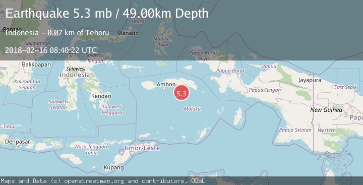
A 5.3 magnitude earthquake struck on BANDA SEA, at Fri, 16 Feb 2018 08:40:22 GMT. Depth: 49km. Reviewed by EMSC seismologists, this moderate quake occurred at a magnitude type of mb.
Magnitude
5.3
mb
Source
EMSC
Intensity
-
Agency Reports
1 Sources| Source | Magnitude | Depth | Time |
|---|---|---|---|
| EMSCPrimary | 5.3 | 49 km | 8 years ago |
Earthquake Details
AutomaticEvent IDemsc_EMSC_20180216_0000039
Tsunami PotentialNo
Magnitude Typemb
Nearest Places
- Pulau Suanggi36.8 km
- Pulau Nailaka56.8 km
- Tanjung Run57.3 km
- Gunung Run57.6 km
- Run58.2 km
Comments
Join the discussion about this event.
Latest Earthquakes
1.3Mag
Southeastern Alaska
Time4 minutes ago
Depth1.71 km
SourceVYT (Automatic)
2.9Mag
Central Alaska
Time9 minutes ago
Depth0.00 km
SourceVYT (Automatic)
1.9Mag
Kenai Peninsula, Alaska
Time10 minutes ago
Depth67.87 km
SourceVYT (Automatic)
1.2Mag
Southeastern Alaska
Time15 minutes ago
Depth35.28 km
SourceVYT (Automatic)
3.3Mag
off the coast of Libertador O'Higgins, Chile
Time19 minutes ago
Depth10.00 km
SourceVYT (Automatic)
Nearby Earthquakes
5.4Mag
BANDA SEA
Time10 years ago
Depth30.00 km
SourceEMSC (Automatic)
5.5Mag
BANDA SEA
Time14 years ago
Depth40.00 km
SourceEMSC (Automatic)
5.0Mag
BANDA SEA
Time6 years ago
Depth110.00 km
SourceEMSC (Automatic)
5.0Mag
BANDA SEA
Time6 years ago
Depth133.00 km
SourceEMSC (Automatic)
5.0Mag
BANDA SEA
Time10 years ago
Depth40.00 km
SourceEMSC (Automatic)