Earthquake MOLUCCA SEA
Mon, 28 Dec 2020 07:31:10 GMT
Time5 years ago
Location
-0.1600, 124.5500
Depth
47.0 KM
Event Summary
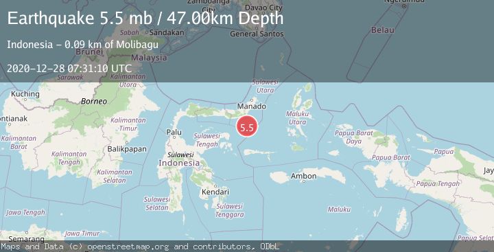
A 5.5 magnitude earthquake struck on MOLUCCA SEA, at Mon, 28 Dec 2020 07:31:10 GMT. Depth: 47km. Reviewed by EMSC seismologists, this moderate quake occurred at a magnitude type of mb.
Magnitude
5.5
mb
Source
EMSC
Intensity
-
Agency Reports
1 Sources| Source | Magnitude | Depth | Time |
|---|---|---|---|
| EMSCPrimary | 5.5 | 47 km | 5 years ago |
Earthquake Details
AutomaticEvent IDemsc_EMSC_20201228_0000056
Tsunami PotentialNo
Magnitude Typemb
Nearest Places
- Gorontalo Basin62.0 km
- Libuton Pondanmointok68.0 km
- Pulau Lampu68.0 km
- Tanjung Payunga68.1 km
- Pulau-pulau Batutolu68.2 km
Comments
Join the discussion about this event.
Latest Earthquakes
2.8Mag
Sunda Strait, Indonesia
Time12 minutes ago
Depth3.61 km
SourceBMKG
3.6Mag
south of Alaska
Time12 minutes ago
Depth10.00 km
SourceVYT (Automatic)
1.2Mag
Central Alaska
Time14 minutes ago
Depth68.97 km
SourceVYT (Automatic)
1.2Mag
Washington
Time16 minutes ago
Depth0.00 km
SourceVYT (Automatic)
0.8Mag
10 km WNW of The Geysers, CA
Time22 minutes ago
Depth1.96 km
SourceUSGS (Automatic)
Nearby Earthquakes
5.1Mag
MOLUCCA SEA
Time5 years ago
Depth29.00 km
SourceEMSC (Automatic)
3.0Mag
Southern Molucca Sea
Time2 weeks ago
Depth12.21 km
SourceBMKG (Automatic)
5.1Mag
MOLUCCA SEA
Time5 years ago
Depth51.00 km
SourceEMSC (Automatic)
5.1Mag
MOLUCCA SEA
Time6 years ago
Depth52.00 km
SourceNEIC (Automatic)
5.3Mag
MOLUCCA SEA
Time18 years ago
Depth70.00 km
SourceEMSC (Automatic)