Earthquake PHILIPPINE ISLANDS REGION
Thu, 21 Jan 2021 12:23:04 GMT
Time5 years ago
Location
5.0200, 127.5300
Depth
92.0 KM
Event Summary
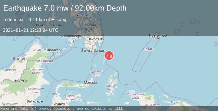
A 7.0 magnitude earthquake struck on PHILIPPINE ISLANDS REGION, at Thu, 21 Jan 2021 12:23:04 GMT. Depth: 92km. Reviewed by EMSC seismologists, this major quake occurred at a magnitude type of mw.
Magnitude
7.0
mw
Source
EMSC
Intensity
-
Agency Reports
1 Sources| Source | Magnitude | Depth | Time |
|---|---|---|---|
| EMSCPrimary | 7.0 | 92 km | 5 years ago |
Earthquake Details
AutomaticEvent IDemsc_EMSC_20210121_0000098
Tsunami PotentialNo
Magnitude Typemw
Nearest Places
- Desa Marampit Timur52.2 km
- Desa Marampit53.0 km
- Kecamatan Nanusa53.5 km
- Pulau Marampit53.6 km
- Desa Dampulis54.0 km
Comments
Join the discussion about this event.
Latest Earthquakes
2.4Mag
Central Alaska
Time18 hours ago
Depth0.24 km
SourceVYT (Automatic)
3.9Mag
North of Halmahera, Indonesia
Time18 hours ago
Depth14.71 km
SourceBMKG
2.9Mag
Sumbawa Region, Indonesia
Time18 hours ago
Depth53.96 km
SourceBMKG
0.8Mag
Southern Alaska
Time18 hours ago
Depth15.50 km
SourceVYT (Automatic)
3.3Mag
Banda Sea
Time18 hours ago
Depth161.74 km
SourceVYT (Automatic)
Nearby Earthquakes
5.0Mag
PHILIPPINE ISLANDS REGION
Time1 month ago
Depth118.90 km
SourceEMSC (Automatic)
5.2Mag
KEPULAUAN TALAUD, INDONESIA
Time11 years ago
Depth128.00 km
SourceEMSC (Automatic)
3.0Mag
KEPULAUAN TALAUD, INDONESIA
Time5 years ago
Depth119.00 km
SourcePIVS (Automatic)
4.8Mag
KEPULAUAN TALAUD, INDONESIA
Time1 month ago
Depth109.00 km
SourceEMSC (Automatic)
3.0Mag
KEPULAUAN TALAUD, INDONESIA
Time7 months ago
Depth71.00 km
SourcePIVS (Automatic)