Earthquake KERMADEC ISLANDS REGION
Mon, 08 Feb 2021 08:06:18 GMT
Time5 years ago
Location
-30.2900, -179.4100
Depth
333.0 KM
Event Summary
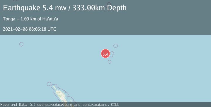
A 5.4 magnitude earthquake struck on KERMADEC ISLANDS REGION, at Mon, 08 Feb 2021 08:06:18 GMT. Depth: 333km. Reviewed by EMSC seismologists, this moderate quake occurred at a magnitude type of mw.
Magnitude
5.4
mw
Source
EMSC
Intensity
-
Agency Reports
1 Sources| Source | Magnitude | Depth | Time |
|---|---|---|---|
| EMSCPrimary | 5.4 | 333 km | 5 years ago |
Earthquake Details
AutomaticEvent IDemsc_EMSC_20210208_0000073
Tsunami PotentialNo
Magnitude Typemw
Nearest Places
- Colville Ridge65.3 km
- Giggenbach Seamount72.0 km
- Cheeseman Island85.2 km
- Stella Passage86.3 km
- Macdonald Cove86.3 km
Comments
Join the discussion about this event.
Latest Earthquakes
4.2Mag
Kepulauan Talaud, Indonesia
Time7 minutes ago
Depth85.57 km
SourceVYT (Automatic)
2.0Mag
Antofagasta, Chile
Time10 minutes ago
Depth127.32 km
SourceVYT (Automatic)
2.0Mag
Southern California
Time19 minutes ago
Depth14.40 km
SourceVYT (Automatic)
3.0Mag
Potosi, Bolivia
Time20 minutes ago
Depth188.11 km
SourceVYT (Automatic)
1.3Mag
9 km WNW of The Geysers, CA
Time21 minutes ago
Depth2.36 km
SourceUSGS (Automatic)
Nearby Earthquakes
6.3Mag
KERMADEC ISLANDS REGION
Time6 years ago
Depth10.00 km
SourceEMSC (Automatic)
5.1Mag
KERMADEC ISLANDS REGION
Time10 years ago
Depth311.00 km
SourceEMSC (Automatic)
5.0Mag
KERMADEC ISLANDS REGION
Time12 years ago
Depth340.00 km
SourceEMSC (Automatic)
5.0Mag
KERMADEC ISLANDS REGION
Time7 years ago
Depth320.00 km
SourceEMSC (Automatic)
5.0Mag
KERMADEC ISLANDS REGION
Time19 years ago
Depth200.00 km
SourceEMSC (Automatic)