Earthquake NEAR N COAST OF PAPUA, INDONESIA
Tue, 16 Feb 2021 19:09:38 GMT
Time5 years ago
Location
-2.8900, 139.2000
Depth
25.0 KM
Event Summary
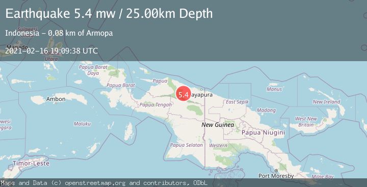
A 5.4 magnitude earthquake struck on NEAR N COAST OF PAPUA, INDONESIA, at Tue, 16 Feb 2021 19:09:38 GMT. Depth: 25km. Reviewed by EMSC seismologists, this moderate quake occurred at a magnitude type of mw.
Magnitude
5.4
mw
Source
EMSC
Intensity
-
Agency Reports
1 Sources| Source | Magnitude | Depth | Time |
|---|---|---|---|
| EMSCPrimary | 5.4 | 25 km | 5 years ago |
Earthquake Details
AutomaticEvent IDemsc_EMSC_20210216_0000140
Tsunami PotentialNo
Magnitude Typemw
Nearest Places
- Kampung Sunum7.3 km
- Distrik Pantai Timur9.6 km
- Kampung Betaf Dua14.2 km
- Kampung Krim Podena19.1 km
- Kampung Fuao19.7 km
Comments
Join the discussion about this event.
Latest Earthquakes
2.8Mag
Antofagasta, Chile
Time6 minutes ago
Depth0.00 km
SourceVYT (Automatic)
3.3Mag
Near North Coast of West Papua
Time7 minutes ago
Depth10.00 km
SourceBMKG
2.5Mag
off the coast of Tarapaca, Chile
Time8 minutes ago
Depth0.00 km
SourceVYT (Automatic)
2.5Mag
Sunda Strait, Indonesia
Time9 minutes ago
Depth8.74 km
SourceBMKG
2.5Mag
Ceram Sea
Time9 minutes ago
Depth5.46 km
SourceBMKG
Nearby Earthquakes
3.4Mag
Near North Coast of West Papua
Time1 week ago
Depth47.81 km
SourceBMKG
5.4Mag
NEAR N COAST OF PAPUA, INDONESIA
Time7 years ago
Depth60.00 km
SourceEMSC (Automatic)
5.8Mag
NEAR N COAST OF PAPUA, INDONESIA
Time5 years ago
Depth40.00 km
SourceEMSC (Automatic)
5.3Mag
PAPUA, INDONESIA
Time1 year ago
Depth46.00 km
SourceEMSC (Automatic)
3.0Mag
NEAR N COAST OF PAPUA, INDONESIA
Time5 years ago
Depth14.00 km
SourceDJA (Automatic)