Earthquake PERU-ECUADOR BORDER REGION
Fri, 16 Jul 2021 20:42:49 GMT
Time4 years ago
Location
-3.6200, -77.3100
Depth
10.0 KM
Event Summary
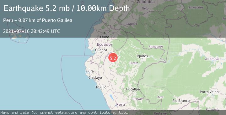
A 5.2 magnitude earthquake struck on PERU-ECUADOR BORDER REGION, at Fri, 16 Jul 2021 20:42:49 GMT. Depth: 10km. Reviewed by EMSC seismologists, this moderate quake occurred at a magnitude type of mb.
Magnitude
5.2
mb
Source
EMSC
Intensity
-
Agency Reports
1 Sources| Source | Magnitude | Depth | Time |
|---|---|---|---|
| EMSCPrimary | 5.2 | 10 km | 4 years ago |
Earthquake Details
AutomaticEvent IDemsc_EMSC_20210716_0000182
Tsunami PotentialNo
Magnitude Typemb
Nearest Places
- Sicuanga5.5 km
- Tacsha-chihuasa6.8 km
- Isla Tigrecantana8.5 km
- Quebrada Chihuaza Grande9.3 km
- Morona9.6 km
Comments
Join the discussion about this event.
Latest Earthquakes
1.2Mag
Southern Alaska
Time2 minutes ago
Depth16.72 km
SourceVYT (Automatic)
3.1Mag
northern Colombia
Time4 minutes ago
Depth219.97 km
SourceVYT (Automatic)
2.2Mag
Sumbawa Region, Indonesia
Time6 minutes ago
Depth15.54 km
SourceBMKG
1.3Mag
WESTERN TURKEY
Time10 minutes ago
Depth9.30 km
SourceAFAD (Automatic)
4.3Mag
east of Australia
Time11 minutes ago
Depth10.00 km
SourceVYT (Automatic)
Nearby Earthquakes
5.4Mag
PERU-ECUADOR BORDER REGION
Time4 years ago
Depth105.00 km
SourceEMSC (Automatic)
5.0Mag
PERU-ECUADOR BORDER REGION
Time20 years ago
Depth80.00 km
SourceEMSC (Automatic)
4.0Mag
PERU-ECUADOR BORDER REGION
Time2 years ago
Depth107.00 km
SourceLIM (Automatic)
5.0Mag
PERU-ECUADOR BORDER REGION
Time3 years ago
Depth112.00 km
SourceEMSC (Automatic)
4.0Mag
PERU-ECUADOR BORDER REGION
Time4 years ago
Depth143.00 km
SourceLIM (Automatic)