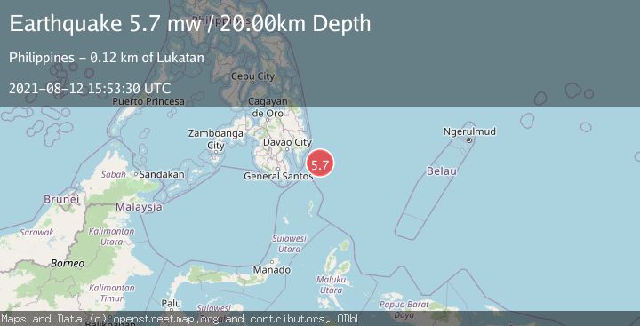
Earthquake PHILIPPINE ISLANDS REGION
Thu, 12 Aug 2021 15:53:30 GMT
Time4 years ago
Location
6.3700, 127.2500
Depth
20.0 KM
Event Summary
A 5.7 magnitude earthquake struck on PHILIPPINE ISLANDS REGION, at Thu, 12 Aug 2021 15:53:30 GMT. Depth: 20km. Reviewed by EMSC seismologists, this moderate quake occurred at a magnitude type of mw.
Magnitude
5.7
mw
Source
EMSC
Intensity
-
Agency Reports
1 Sources| Source | Magnitude | Depth | Time |
|---|---|---|---|
| EMSCPrimary | 5.7 | 20 km | 4 years ago |
Earthquake Details
AutomaticEvent IDemsc_EMSC_20210812_0000168
Tsunami PotentialNo
Magnitude Typemw
Nearest Places
- Cateel101.2 km
- Lamigan Point110.4 km
- Mayo Bay111.5 km
- Tugubun Point111.7 km
- Taganilac112.4 km
Comments
Join the discussion about this event.
Latest Earthquakes
2.5Mag
Java, Indonesia
Time5 minutes ago
Depth35.11 km
SourceBMKG
1.4Mag
13 km N of Meadow Lakes, Alaska
Time12 minutes ago
Depth28.30 km
SourceUSGS (Automatic)
2.2Mag
West Papua Region, Indonesia
Time12 minutes ago
Depth72.97 km
SourceBMKG
2.1Mag
Southern Alaska
Time12 minutes ago
Depth0.00 km
SourceVYT (Automatic)
2.5Mag
SOUTHERN GREECE
Time19 minutes ago
Depth17.20 km
SourceNOA (Automatic)
Nearby Earthquakes
3.0Mag
PHILIPPINE ISLANDS REGION
Time3 months ago
Depth15.00 km
SourcePIVS (Automatic)
3.0Mag
PHILIPPINE ISLANDS REGION
Time4 years ago
Depth35.00 km
SourcePIVS (Automatic)
3.0Mag
PHILIPPINE ISLANDS REGION
Time1 year ago
Depth160.00 km
SourcePIVS (Automatic)
3.0Mag
PHILIPPINE ISLANDS REGION
Time4 years ago
Depth38.00 km
SourcePIVS (Automatic)
3.0Mag
PHILIPPINE ISLANDS REGION
Time1 year ago
Depth27.00 km
SourcePIVS (Automatic)