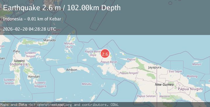
Earthquake West Papua Region, Indonesia
Fri, 20 Feb 2026 04:28:30 GMT
Time1 hour ago
Location
-0.8584, 133.1264
Depth
73.0 KM
Event Summary
A 2.2 magnitude earthquake struck on West Papua Region, Indonesia, at Fri, 20 Feb 2026 04:28:30 GMT. Depth: 72.968842km. Reviewed by BMKG seismologists, this minor quake occurred at a magnitude type of M.
Magnitude
2.2
M
Source
BMKG
Intensity
-
Agency Reports
1 Sources| Source | Magnitude | Depth | Time |
|---|---|---|---|
| BMKGPrimary | 2.2 | 73 km | 1 hour ago |
Earthquake Details
ManualEvent IDbmg2026dnsa
Tsunami PotentialNo
Magnitude TypeM
Nearest Places
- Kampung Wabanek1.2 km
- Kebar2.5 km
- Kampung Apoki2.6 km
- Kampung Karawi3.6 km
- Kampung Matatun4.2 km
Comments
Join the discussion about this event.
Latest Earthquakes
1.4Mag
13 km N of Meadow Lakes, Alaska
Time1 hour ago
Depth28.30 km
SourceUSGS (Automatic)
2.1Mag
Southern Alaska
Time1 hour ago
Depth0.00 km
SourceVYT (Automatic)
2.5Mag
SOUTHERN GREECE
Time1 hour ago
Depth17.20 km
SourceNOA (Automatic)
3.1Mag
Caribbean Sea
Time1 hour ago
Depth226.81 km
SourceVYT (Automatic)
3.4Mag
West Papua Region, Indonesia
Time1 hour ago
Depth54.58 km
SourceBMKG
Nearby Earthquakes
2.4Mag
West Papua Region, Indonesia
Time3 weeks ago
Depth10.00 km
SourceBMKG (Automatic)
2.1Mag
West Papua Region, Indonesia
Time3 weeks ago
Depth14.74 km
SourceBMKG (Automatic)
5.5Mag
NEAR N COAST OF PAPUA, INDONESIA
Time13 years ago
Depth17.00 km
SourceEMSC (Automatic)
2.4Mag
West Papua Region, Indonesia
Time1 week ago
Depth12.73 km
SourceBMKG (Automatic)
3.0Mag
NEAR N COAST OF PAPUA, INDONESIA
Time5 years ago
Depth21.00 km
SourceDJA (Automatic)