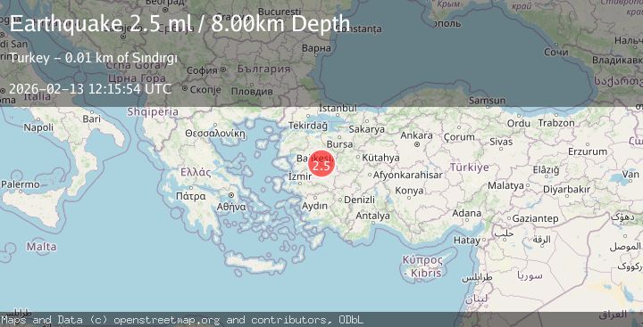
Earthquake WESTERN TURKEY
Fri, 13 Feb 2026 12:15:53 GMT
Time5 days ago
Location
39.1868, 28.1830
Depth
13.3 KM
Event Summary
A 2.7 magnitude earthquake struck on WESTERN TURKEY, at Fri, 13 Feb 2026 12:15:53 GMT. Depth: 13.3km. Reviewed by KOERI seismologists, this minor quake occurred at a magnitude type of ml.
Magnitude
2.7
ml
Source
KOERI
Intensity
-
Agency Reports
3 Sources| Source | Magnitude | Depth | Time |
|---|---|---|---|
| KOERIPrimary | 2.7 | 13 km | 5 days ago |
| AFAD | 2.5 | 8 km | 5 days ago |
| EMSC | 2.5 | 8 km | 5 days ago |
Earthquake Details
AutomaticEvent IDemsc_KOERI_20260213_0000168
Tsunami PotentialNo
Magnitude Typeml
Nearest Places
- Yaylacık2.6 km
- Aktaş2.9 km
- Sinandede3.2 km
- Söğütlü Dere3.9 km
- Ormaniçi4.3 km
Comments
Join the discussion about this event.
Latest Earthquakes
1.5Mag
Alaska Peninsula
Time15 hours ago
Depth31.37 km
SourceVYT (Automatic)
1.4Mag
Kenai Peninsula, Alaska
Time15 hours ago
Depth35.28 km
SourceVYT (Automatic)
1.1Mag
87 km N of Karluk, Alaska
Time15 hours ago
Depth5.00 km
SourceUSGS (Automatic)
2.3Mag
Southern Sumatra, Indonesia
Time15 hours ago
Depth36.72 km
SourceBMKG
2.6Mag
Java, Indonesia
Time15 hours ago
Depth62.13 km
SourceBMKG
Nearby Earthquakes
3.0Mag
WESTERN TURKEY
Time1 month ago
Depth16.50 km
SourceEMSC (Automatic)
1.8Mag
WESTERN TURKEY
Time1 month ago
Depth6.30 km
SourceAFAD (Automatic)
1.7Mag
WESTERN TURKEY
Time1 month ago
Depth11.30 km
SourceEMSC (Automatic)
1.5Mag
WESTERN TURKEY
Time2 weeks ago
Depth11.60 km
SourceAFAD (Automatic)
1.5Mag
WESTERN TURKEY
Time1 week ago
Depth8.80 km
SourceAFAD (Automatic)