Earthquake MOLUCCA SEA
Wed, 13 May 2020 16:45:13 GMT
Time5 years ago
Location
2.0300, 127.6800
Depth
190.0 KM
Event Summary
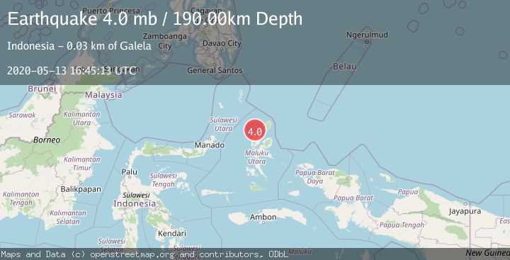
A 4.0 magnitude earthquake struck on MOLUCCA SEA, at Wed, 13 May 2020 16:45:13 GMT. Depth: 190km. Reviewed by NEIC seismologists, this light quake occurred at a magnitude type of mb.
Magnitude
4.0
mb
Source
NEIC
Intensity
-
Agency Reports
1 Sources| Source | Magnitude | Depth | Time |
|---|---|---|---|
| NEICPrimary | 4.0 | 190 km | 5 years ago |
Earthquake Details
AutomaticEvent IDemsc_NEIC_20200513_0000172
Tsunami PotentialNo
Magnitude Typemb
Nearest Places
- Pulau Diti9.3 km
- Tanjung Tibur9.5 km
- Ake Jangailulu10.0 km
- Jangailulu10.0 km
- Tanjung Asimiro10.1 km
Comments
Join the discussion about this event.
Latest Earthquakes
3.0Mag
northern Sumatra, Indonesia
Time1 minute ago
Depth10.50 km
SourceVYT (Automatic)
1.6Mag
Kenai Peninsula, Alaska
Time9 minutes ago
Depth42.60 km
SourceVYT (Automatic)
2.4Mag
Finland
Time11 minutes ago
Depth301.88 km
SourceVYT (Automatic)
1.2Mag
Alaska Peninsula
Time12 minutes ago
Depth0.12 km
SourceVYT (Automatic)
2.6Mag
SAN JUAN, ARGENTINA
Time13 minutes ago
Depth92.00 km
SourceNSNA (Automatic)
Nearby Earthquakes
3.5Mag
Halmahera, Indonesia
Time2 days ago
Depth23.32 km
SourceVYT (Automatic)
3.2Mag
MOLUCCA SEA
Time1 month ago
Depth4.00 km
SourceBMKG (Automatic)
4.0Mag
MOLUCCA SEA
Time2 years ago
Depth10.00 km
SourceBMKG (Automatic)
3.0Mag
HALMAHERA, INDONESIA
Time3 years ago
Depth43.00 km
SourceDJA (Automatic)
3.2Mag
Northern Molucca Sea
Time2 weeks ago
Depth227.49 km
SourceBMKG (Automatic)