Earthquake SOUTHERN CALIFORNIA
Mon, 22 Feb 2021 00:28:09 GMT
Time4 years ago
Location
33.9900, -116.8000
Depth
10.0 KM
Event Summary
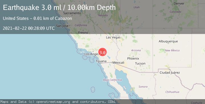
A 3.0 magnitude earthquake struck on SOUTHERN CALIFORNIA, at Mon, 22 Feb 2021 00:28:09 GMT. Depth: 10km. Reviewed by NEIC seismologists, this minor quake occurred at a magnitude type of ml.
Magnitude
3.0
ml
Source
NEIC
Intensity
-
Agency Reports
1 Sources| Source | Magnitude | Depth | Time |
|---|---|---|---|
| NEICPrimary | 3.0 | 10 km | 4 years ago |
Earthquake Details
AutomaticEvent IDemsc_NEIC_20210222_0000001
Tsunami PotentialNo
Magnitude Typeml
Nearest Places
- Millard Canyon Guard Station1.3 km
- East Branch Millard Canyon1.4 km
- West Branch Millard Canyon2.4 km
- San Gorgonio Pass2.7 km
- Corral Canyon2.7 km
Comments
Join the discussion about this event.
Latest Earthquakes
2.3Mag
Tarapaca, Chile
Time2 minutes ago
Depth114.14 km
SourceVYT (Automatic)
2.1Mag
Southern Alaska
Time7 minutes ago
Depth67.26 km
SourceVYT (Automatic)
2.2Mag
western Russia
Time9 minutes ago
Depth0.00 km
SourceVYT (Automatic)
1.5Mag
4 km NNW of The Geysers, CA
Time10 minutes ago
Depth-0.27 km
SourceUSGS (Automatic)
1.0Mag
9 km WNW of Two Rivers, Alaska
Time11 minutes ago
Depth5.70 km
SourceUSGS (Automatic)
Nearby Earthquakes
3.0Mag
SOUTHERN CALIFORNIA
Time6 months ago
Depth11.20 km
SourceSCSN (Automatic)
2.1Mag
SOUTHERN CALIFORNIA
Time1 month ago
Depth16.80 km
SourceSCSN (Automatic)
3.0Mag
SOUTHERN CALIFORNIA
Time10 years ago
Depth18.00 km
SourceNEIR (Automatic)
2.8Mag
SOUTHERN CALIFORNIA
Time1 month ago
Depth10.00 km
SourceNEIC (Automatic)
1.2Mag
10 km NNE of Cabazon, CA
Time2 weeks ago
Depth17.19 km
SourceUSGS (Automatic)