Earthquake SOUTHERN CALIFORNIA
Fri, 02 Jan 2026 07:16:42 GMT
Time1 month ago
Location
34.0042, -116.8327
Depth
16.8 KM
Event Summary
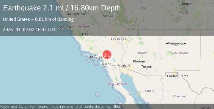
A 2.1 magnitude earthquake struck on SOUTHERN CALIFORNIA, at Fri, 02 Jan 2026 07:16:42 GMT. Depth: 16.8km. Reviewed by SCSN seismologists, this minor quake occurred at a magnitude type of ml.
Magnitude
2.1
ml
Source
SCSN
Intensity
-
Agency Reports
1 Sources| Source | Magnitude | Depth | Time |
|---|---|---|---|
| SCSNPrimary | 2.1 | 17 km | 1 month ago |
Earthquake Details
AutomaticEvent IDemsc_SCSN_20260102_0000092
Tsunami PotentialNo
Magnitude Typeml
Nearest Places
- Wood Canyon1.6 km
- Burro Flats1.7 km
- Corral Canyon3.3 km
- West Branch Hathaway Creek3.4 km
- Big Oaks Powerhouse3.7 km
Comments
Join the discussion about this event.
Latest Earthquakes
2.1Mag
Tarapaca, Chile
Time4 minutes ago
Depth8.18 km
SourceVYT (Automatic)
1.4Mag
12 km ESE of Olancha, CA
Time5 minutes ago
Depth7.15 km
SourceUSGS (Automatic)
2.8Mag
northwestern Russia
Time6 minutes ago
Depth10.00 km
SourceVYT (Automatic)
3.3Mag
Near North Coast of West Papua
Time6 minutes ago
Depth10.00 km
SourceBMKG
1.2Mag
5 km NNE of Fishhook, Alaska
Time7 minutes ago
Depth0.80 km
SourceUSGS (Automatic)
Nearby Earthquakes
1.4Mag
8 km NNE of Banning, CA
Time3 weeks ago
Depth12.57 km
SourceUSGS (Automatic)
1.1Mag
6 km NNE of Banning, CA
Time3 weeks ago
Depth8.23 km
SourceUSGS (Automatic)
3.0Mag
SOUTHERN CALIFORNIA
Time4 years ago
Depth10.00 km
SourceNEIC (Automatic)
1.1Mag
12 km N of Banning, CA
Time1 week ago
Depth12.38 km
SourceUSGS (Automatic)
3.0Mag
SOUTHERN CALIFORNIA
Time10 years ago
Depth18.00 km
SourceNEIR (Automatic)