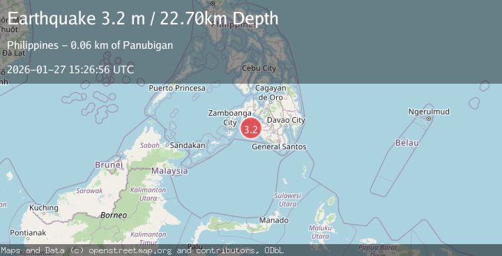
Earthquake MORO GULF, MINDANAO, PHILIPPINES
Tue, 27 Jan 2026 15:26:56 GMT
Time0 months ago
Location
6.8913, 123.4375
Depth
22.7 KM
Event Summary
A 3.2 magnitude earthquake struck on MORO GULF, MINDANAO, PHILIPPINES, at Tue, 27 Jan 2026 15:26:56 GMT. Depth: 22.7km. Reviewed by NEIC seismologists, this minor quake occurred at a magnitude type of m.
Magnitude
3.2
m
Source
NEIC
Intensity
-
Agency Reports
1 Sources| Source | Magnitude | Depth | Time |
|---|---|---|---|
| NEICPrimary | 3.2 | 23 km | 0 months ago |
Earthquake Details
AutomaticEvent IDemsc_NEIC_20260127_0000274
Tsunami PotentialNo
Magnitude Typem
Nearest Places
- 48.5 km
- 52.1 km
- 52.5 km
- 53.3 km
- 53.7 km
Comments
Join the discussion about this event.
Latest Earthquakes
2.2Mag
Timor Region
Time6 hours ago
Depth4.64 km
SourceBMKG
2.9Mag
Albania
Time6 hours ago
Depth7.20 km
SourceVYT (Automatic)
4.7Mag
Andreanof Islands, Aleutian Islands, Alaska
Time6 hours ago
Depth35.28 km
SourceVYT (Automatic)
3.9Mag
Tarapaca, Chile
Time6 hours ago
Depth114.50 km
SourceVYT (Automatic)
1.2Mag
2 km SSE of The Geysers, CA
Time6 hours ago
Depth1.32 km
SourceUSGS (Automatic)
Nearby Earthquakes
5.2Mag
MORO GULF, MINDANAO, PHILIPPINES
Time15 years ago
Depth618.00 km
SourceEMSC (Automatic)
5.9Mag
Mindanao, Philippines
Time3 weeks ago
Depth197.88 km
SourceBMKG (Automatic)
6.5Mag
MORO GULF, MINDANAO, PHILIPPINES
Time16 years ago
Depth628.00 km
SourceEMSC (Automatic)
7.4Mag
MORO GULF, MINDANAO, PHILIPPINES
Time15 years ago
Depth639.00 km
SourceEMSC (Automatic)
7.3Mag
MORO GULF, MINDANAO, PHILIPPINES
Time15 years ago
Depth600.00 km
SourceEMSC (Automatic)