Earthquake MORO GULF, MINDANAO, PHILIPPINES
Wed, 28 Jan 2026 05:38:54 GMT
Time3 weeks ago
Location
6.2705, 123.7605
Depth
10.0 KM
Event Summary
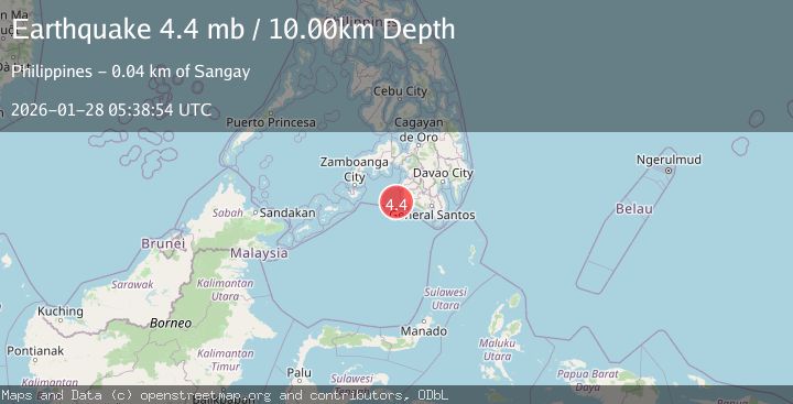
A 4.4 magnitude earthquake struck on MORO GULF, MINDANAO, PHILIPPINES, at Wed, 28 Jan 2026 05:38:54 GMT. Depth: 10km. Reviewed by NEIC seismologists, this light quake occurred at a magnitude type of mb.
Magnitude
4.4
mb
Source
NEIC
Intensity
-
Agency Reports
1 Sources| Source | Magnitude | Depth | Time |
|---|---|---|---|
| NEICPrimary | 4.4 | 10 km | 3 weeks ago |
Earthquake Details
AutomaticEvent IDemsc_NEIC_20260128_0000096
Tsunami PotentialNo
Magnitude Typemb
Nearest Places
- 34.8 km
- 35.0 km
- 35.0 km
- 35.0 km
- 35.3 km
Comments
Join the discussion about this event.
Latest Earthquakes
2.2Mag
Region Metropolitana, Chile
Time3 minutes ago
Depth95.46 km
SourceVYT (Automatic)
1.8Mag
Sweden
Time7 minutes ago
Depth7.08 km
SourceVYT (Automatic)
3.5Mag
South of Java, Indonesia
Time7 minutes ago
Depth10.00 km
SourceBMKG
1.4Mag
Kenai Peninsula, Alaska
Time7 minutes ago
Depth30.15 km
SourceVYT (Automatic)
2.1Mag
Java, Indonesia
Time8 minutes ago
Depth5.73 km
SourceBMKG
Nearby Earthquakes
2.2Mag
Mindanao, Philippines
Time2 weeks ago
Depth36.00 km
SourceMAN (Automatic)
3.3Mag
MORO GULF, MINDANAO, PHILIPPINES
Time3 weeks ago
Depth10.00 km
SourceNEIC (Automatic)
4.3Mag
Mindanao, Philippines
Time3 weeks ago
Depth116.84 km
SourceBMKG (Automatic)
3.5Mag
MORO GULF, MINDANAO, PHILIPPINES
Time3 weeks ago
Depth10.00 km
SourceNEIC (Automatic)
3.1Mag
MORO GULF, MINDANAO, PHILIPPINES
Time1 month ago
Depth20.00 km
SourcePIVS (Automatic)