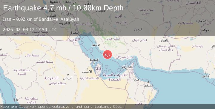
Earthquake SOUTHERN IRAN
Wed, 04 Feb 2026 17:17:50 GMT
Time3 hours ago
Location
27.3087, 52.5895
Depth
10.0 KM
Event Summary
A 4.7 magnitude earthquake struck on SOUTHERN IRAN, at Wed, 04 Feb 2026 17:17:50 GMT. Depth: 10km. Reviewed by NEIC seismologists, this light quake occurred at a magnitude type of mb.
Magnitude
4.7
mb
Source
NEIC
Intensity
-
Agency Reports
1 Sources| Source | Magnitude | Depth | Time |
|---|---|---|---|
| NEICPrimary | 4.7 | 10 km | 3 hours ago |
Earthquake Details
AutomaticEvent IDemsc_NEIC_20260204_0000230
Tsunami PotentialNo
Magnitude Typemb
Nearest Places
- Bandar-e Bar Kūh5.8 km
- Kūh-e Bar Kūh6.0 km
- Manţaqeh-ye Damāgheh-ye Nāy Band8.8 km
- Bandar-e ‘Arāb8.9 km
- Manţaqeh-ye Nāy Band9.0 km
Comments
Join the discussion about this event.
Latest Earthquakes
3.4Mag
PHILIPPINE ISLANDS REGION
Time3 hours ago
Depth9.00 km
SourcePIVS (Automatic)
2.9Mag
Timor Region
Time3 hours ago
Depth0.00 km
SourceBMKG (Automatic)
3.4Mag
CRETE, GREECE
Time3 hours ago
Depth48.00 km
SourceNOA (Automatic)
1.1Mag
1 km NNW of Fairview, CA
Time3 hours ago
Depth20.54 km
SourceUSGS (Automatic)
2.3Mag
West Papua Region, Indonesia
Time3 hours ago
Depth10.00 km
SourceBMKG (Automatic)
Nearby Earthquakes
5.4Mag
SOUTHERN IRAN
Time3 days ago
Depth24.00 km
SourceEMSC (Automatic)
5.1Mag
SOUTHERN IRAN
Time1 week ago
Depth28.00 km
SourceEMSC (Automatic)
4.4Mag
SOUTHERN IRAN
Time1 week ago
Depth10.00 km
SourceGFZ (Automatic)
4.5Mag
SOUTHERN IRAN
Time1 week ago
Depth57.30 km
SourceNEIC (Automatic)
4.5Mag
104 km N of Mīnāb, Iran
Time1 week ago
Depth57.35 km
SourceUSGS