Earthquake ISLAND OF HAWAII, HAWAII
Mon, 30 Nov 2015 06:08:51 GMT
Time10 years ago
Location
19.0400, -155.4300
Depth
35.0 KM
Event Summary
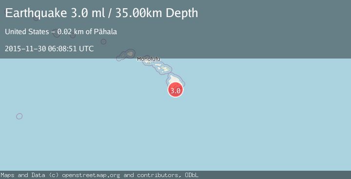
A 3.0 magnitude earthquake struck on ISLAND OF HAWAII, HAWAII, at Mon, 30 Nov 2015 06:08:51 GMT. Depth: 35km. Reviewed by NEIR seismologists, this minor quake occurred at a magnitude type of ml.
Magnitude
3.0
ml
Source
NEIR
Intensity
-
Agency Reports
1 Sources| Source | Magnitude | Depth | Time |
|---|---|---|---|
| NEIRPrimary | 3.0 | 35 km | 10 years ago |
Earthquake Details
AutomaticEvent IDemsc_NEIR_20151130_0000018
Tsunami PotentialNo
Magnitude Typeml
Nearest Places
- Ahole Heiau11.2 km
- Kamehame Beach12.2 km
- Kamehame Hill12.3 km
- Pu‘upili12.3 km
- Puuo Point12.3 km
Comments
Join the discussion about this event.
Latest Earthquakes
1.8Mag
8 km SSW of Dayton, Nevada
Time3 minutes ago
Depth2.65 km
SourceUSGS (Automatic)
1.4Mag
6 km SSW of Idyllwild, CA
Time8 minutes ago
Depth15.02 km
SourceUSGS (Automatic)
2.4Mag
western Texas
Time10 minutes ago
Depth6.10 km
SourceVYT (Automatic)
2.8Mag
Southern Alaska
Time12 minutes ago
Depth14.04 km
SourceVYT (Automatic)
2.4Mag
Southern Alaska
Time14 minutes ago
Depth139.28 km
SourceVYT (Automatic)
Nearby Earthquakes
2.0Mag
ISLAND OF HAWAII, HAWAII
Time1 month ago
Depth34.00 km
SourceHV (Automatic)
3.2Mag
14 km ESE of Naalehu, Hawaii
Time1 week ago
Depth32.41 km
SourceUSGS (Automatic)
3.0Mag
ISLAND OF HAWAII, HAWAII
Time0 years ago
Depth43.80 km
SourceNEIC (Automatic)
1.7Mag
18 km ESE of Naalehu, Hawaii
Time1 week ago
Depth34.75 km
SourceUSGS (Automatic)
3.0Mag
ISLAND OF HAWAII, HAWAII
Time10 months ago
Depth34.00 km
SourceHV (Automatic)