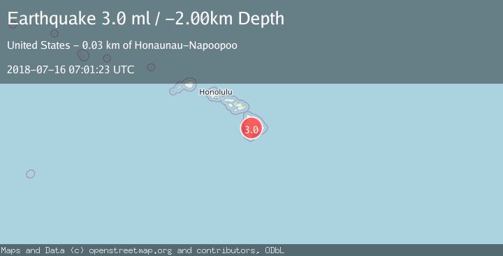
Earthquake ISLAND OF HAWAII, HAWAII
Mon, 16 Jul 2018 07:01:23 GMT
Time7 years ago
Location
19.4800, -155.5900
Depth
-2.0 KM
Event Summary
A 3.0 magnitude earthquake struck on ISLAND OF HAWAII, HAWAII, at Mon, 16 Jul 2018 07:01:23 GMT. Depth: -2km. Reviewed by NEIR seismologists, this minor quake occurred at a magnitude type of ml.
Magnitude
3.0
ml
Source
NEIR
Intensity
-
Agency Reports
1 Sources| Source | Magnitude | Depth | Time |
|---|---|---|---|
| NEIRPrimary | 3.0 | -2 km | 7 years ago |
Earthquake Details
AutomaticEvent IDemsc_NEIR_20180716_0000146
Tsunami PotentialNo
Magnitude Typeml
Nearest Places
- Moku‘āweoweo Caldera0.4 km
- Maunaloa0.9 km
- Wilkes Camp1.3 km
- Summit Patrol Cabin1.3 km
- Mauna Loa Summit Cairn1.3 km
Comments
Join the discussion about this event.
Latest Earthquakes
1.0Mag
Northern Territory, Australia
Time19 hours ago
Depth0.00 km
SourceVYT (Automatic)
1.8Mag
Southern Alaska
Time19 hours ago
Depth20.39 km
SourceVYT (Automatic)
2.2Mag
Minahasa, Sulawesi, Indonesia
Time20 hours ago
Depth46.75 km
SourceVYT (Automatic)
3.2Mag
Minahassa Peninsula, Sulawesi
Time20 hours ago
Depth6.62 km
SourceBMKG
1.5Mag
Region Metropolitana, Chile
Time20 hours ago
Depth0.12 km
SourceVYT (Automatic)
Nearby Earthquakes
3.0Mag
ISLAND OF HAWAII, HAWAII
Time3 years ago
Depth4.00 km
SourceNEIC (Automatic)
3.0Mag
ISLAND OF HAWAII, HAWAII
Time3 years ago
Depth0.00 km
SourceNEIC (Automatic)
2.6Mag
ISLAND OF HAWAII, HAWAII
Time1 month ago
Depth-2.50 km
SourceHV (Automatic)
2.2Mag
ISLAND OF HAWAII, HAWAII
Time1 week ago
Depth-1.70 km
SourceHV (Automatic)
2.9Mag
ISLAND OF HAWAII, HAWAII
Time1 month ago
Depth43.20 km
SourceHV (Automatic)