Earthquake PHILIPPINE ISLANDS REGION
Mon, 26 Feb 2024 17:20:35 GMT
Time1 year ago
Location
10.7700, 126.8500
Depth
33.0 KM
Event Summary
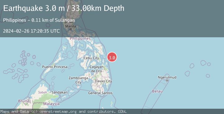
A 3.0 magnitude earthquake struck on PHILIPPINE ISLANDS REGION, at Mon, 26 Feb 2024 17:20:35 GMT. Depth: 33km. Reviewed by PIVS seismologists, this minor quake occurred at a magnitude type of m.
Magnitude
3.0
m
Source
PIVS
Intensity
-
Agency Reports
1 Sources| Source | Magnitude | Depth | Time |
|---|---|---|---|
| PIVSPrimary | 3.0 | 33 km | 1 year ago |
Earthquake Details
AutomaticEvent IDemsc_PIVS_20240226_0000284
Tsunami PotentialNo
Magnitude Typem
Nearest Places
- Homonhon Seamount21.4 km
- Suluan Seamount23.0 km
- Emden Deep30.4 km
- Candulo Ridge63.5 km
- Suluan Lighthouse96.6 km
Comments
Join the discussion about this event.
Latest Earthquakes
1.1Mag
10 km WNW of The Geysers, CA
Time5 minutes ago
Depth2.07 km
SourceUSGS (Automatic)
1.6Mag
Southern Alaska
Time9 minutes ago
Depth0.12 km
SourceVYT (Automatic)
1.5Mag
Southeastern Alaska
Time12 minutes ago
Depth13.67 km
SourceVYT (Automatic)
4.8Mag
offshore Coquimbo, Chile
Time14 minutes ago
Depth0.00 km
SourceVYT (Automatic)
3.4Mag
Timor Region
Time14 minutes ago
Depth128.23 km
SourceBMKG
Nearby Earthquakes
5.1Mag
PHILIPPINE ISLANDS REGION
Time13 years ago
Depth10.00 km
SourceEMSC (Automatic)
5.3Mag
PHILIPPINE ISLANDS REGION
Time13 years ago
Depth40.00 km
SourceEMSC (Automatic)
5.1Mag
PHILIPPINE ISLANDS REGION
Time12 years ago
Depth40.00 km
SourceEMSC (Automatic)
5.3Mag
PHILIPPINE ISLANDS REGION
Time13 years ago
Depth10.00 km
SourceEMSC (Automatic)
5.0Mag
PHILIPPINE ISLANDS REGION
Time13 years ago
Depth13.00 km
SourceEMSC (Automatic)