Earthquake GULF OF CALIFORNIA
Sat, 24 Jan 2026 13:37:19 GMT
Time1 week ago
Location
27.8520, -111.9250
Depth
5.0 KM
Event Summary
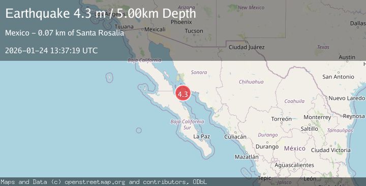
A 4.3 magnitude earthquake struck on GULF OF CALIFORNIA, at Sat, 24 Jan 2026 13:37:19 GMT. Depth: 5km. Reviewed by UNM seismologists, this light quake occurred at a magnitude type of m.
Magnitude
4.3
m
Source
UNM
Intensity
-
Agency Reports
1 Sources| Source | Magnitude | Depth | Time |
|---|---|---|---|
| UNMPrimary | 4.3 | 5 km | 1 week ago |
Earthquake Details
AutomaticEvent IDemsc_UNM_20260124_0000256
Tsunami PotentialNo
Magnitude Typem
Nearest Places
- Isla Tortuga45.9 km
- Cabo Vírgenes54.3 km
- Punta Gorda54.4 km
- Punta El Gato54.5 km
- Punta Norte54.9 km
Comments
Join the discussion about this event.
Latest Earthquakes
3.5Mag
Talaud Islands, Indonesia
Time9 minutes ago
Depth41.43 km
SourceBMKG (Automatic)
1.3Mag
11 km WSW of Searles Valley, CA
Time13 minutes ago
Depth2.72 km
SourceUSGS (Automatic)
2.2Mag
Sulawesi, Indonesia
Time17 minutes ago
Depth1.82 km
SourceBMKG (Automatic)
2.1Mag
Java, Indonesia
Time17 minutes ago
Depth31.01 km
SourceBMKG (Automatic)
2.6Mag
Near North Coast of West Papua
Time24 minutes ago
Depth10.00 km
SourceBMKG (Automatic)
Nearby Earthquakes
4.2Mag
GULF OF CALIFORNIA
Time6 hours ago
Depth8.10 km
SourceUNM (Automatic)
4.1Mag
GULF OF CALIFORNIA
Time1 week ago
Depth10.00 km
SourceUNM (Automatic)
1.9Mag
9 km SSW of Alberto Oviedo Mota, B.C., MX
Time1 week ago
Depth7.51 km
SourceUSGS (Automatic)
2.7Mag
16 km W of Alberto Oviedo Mota, B.C., MX
Time2 weeks ago
Depth2.27 km
SourceUSGS
2.2Mag
BAJA CALIFORNIA, MEXICO
Time1 week ago
Depth1.20 km
SourceSCSN (Automatic)