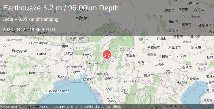
Earthquake MYANMAR-INDIA BORDER REGION
Fri, 24 Apr 2026 18:30:59 GMT
Time6 days ago
Location
25.2100, 94.8170
Depth
96.0 KM
Event Summary
A 3.2 magnitude earthquake struck on MYANMAR-INDIA BORDER REGION, at Fri, 24 Apr 2026 18:30:59 GMT. Depth: 96km. Reviewed by NDI seismologists, this minor quake occurred at a magnitude type of m.
Magnitude
3.2
m
Source
NDI
Intensity
-
Agency Reports
1 Sources| Source | Magnitude | Depth | Time |
|---|---|---|---|
| NDIPrimary | 3.2 | 96 km | 6 days ago |
Earthquake Details
AutomaticEvent IDemsc_ndi_20260424_0000348
QualityS
Tsunami PotentialNo
Magnitude Typem
Last Update6 days ago
Felt Reports0
Did you feel this earthquake? Report it to help others.
No reports yet
Be the first to report this earthquake!
Latest Earthquakes
Loading...
Nearby Earthquakes
3.3Mag
MYANMAR-INDIA BORDER REGION
Time2 days ago
Depth110.00 km
SourceNDI (Automatic)
3.4Mag
Myanmar-India border region
Time2 days ago
Depth124.27 km
SourceVYT (Automatic)
3.6Mag
Myanmar
Time4 days ago
Depth107.42 km
SourceVYT (Automatic)
3.3Mag
MYANMAR-INDIA BORDER REGION
Time1 week ago
Depth68.00 km
SourceNDI (Automatic)
3.3Mag
MYANMAR-INDIA BORDER REGION
Time1 week ago
Depth56.00 km
SourceNDI (Automatic)