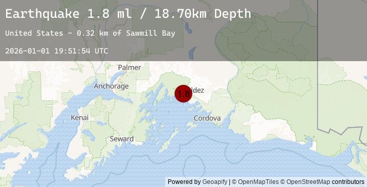
Earthquake 22 km NNW of Tatitlek, Alaska
Thu, 01 Jan 2026 19:51:54 GMT
Time2 hours ago
Location
61.0570, -146.7800
Depth
18.7 KM
Event Summary
A 1.8 magnitude earthquake struck on 22 km NNW of Tatitlek, Alaska, at Thu, 01 Jan 2026 19:51:54 GMT. Depth: 18.7km. Reviewed by USGS seismologists, this minor quake occurred at a magnitude type of ml.
Magnitude
1.8
ml
Source
USGS
Intensity
-
Agency Reports
1 Sources| Source | Magnitude | Depth | Time |
|---|---|---|---|
| USGSPrimary | 1.8 | 19 km | 2 hours ago |
Earthquake Details
AutomaticEvent IDusgs_ak2026abnnco
Tsunami PotentialNo
Magnitude Typeml
Nearest Places
- Sawmill Bay0.3 km
- Sawmill Bay State Marine Park0.6 km
- Stellar Creek1.3 km
- Twin Falls Creek1.5 km
- Point Lowe1.6 km
Comments
Join the discussion about this event.
Latest Earthquakes
2.2Mag
11 km ENE of Willow, Alaska
Time25 minutes ago
Depth28.80 km
SourceUSGS (Automatic)
0.8Mag
10 km WNW of The Geysers, CA
Time34 minutes ago
Depth2.55 km
SourceUSGS (Automatic)
2.3Mag
Minahassa Peninsula, Sulawesi
Time36 minutes ago
Depth10.00 km
SourceBMKG (Automatic)
1.7Mag
15 km SW of Hope, Alaska
Time37 minutes ago
Depth39.30 km
SourceUSGS (Automatic)
5.2Mag
VANUATU
Time38 minutes ago
Depth142.60 km
SourceNEIC (Automatic)
Nearby Earthquakes
No significant earthquakes nearby recently.