Earthquake 135 km E of Chignik, Alaska
Sat, 03 Jan 2026 07:34:09 GMT
Time2 days ago
Location
56.3310, -156.2130
Depth
76.9 KM
Event Summary
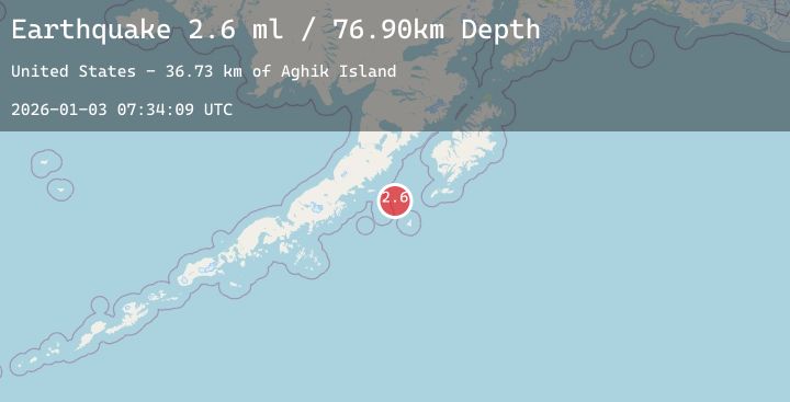
A 2.6 magnitude earthquake struck on 135 km E of Chignik, Alaska, at Sat, 03 Jan 2026 07:34:09 GMT. Depth: 76.9km. Reviewed by USGS seismologists, this minor quake occurred at a magnitude type of ml.
Magnitude
2.6
ml
Source
USGS
Intensity
-
Agency Reports
1 Sources| Source | Magnitude | Depth | Time |
|---|---|---|---|
| USGSPrimary | 2.6 | 77 km | 2 days ago |
Earthquake Details
AutomaticEvent IDusgs_ak2026aegneq
Tsunami PotentialNo
Magnitude Typeml
Nearest Places
- Aghik Island36.7 km
- Anowik Island38.9 km
- Aghiyuk Island39.3 km
- Kiliktagik Island39.4 km
- Suklik Island40.9 km
Comments
Join the discussion about this event.
Latest Earthquakes
0.7Mag
62 km E of Port Alsworth, Alaska
Time2 days ago
Depth5.00 km
SourceUSGS (Automatic)
2.2Mag
PUERTO RICO
Time2 days ago
Depth12.40 km
SourcePR (Automatic)
1.7Mag
52 km W of Tyonek, Alaska
Time2 days ago
Depth99.70 km
SourceUSGS (Automatic)
4.0Mag
OFFSHORE GUERRERO, MEXICO
Time2 days ago
Depth4.30 km
SourceUNM (Automatic)
3.0Mag
MYANMAR
Time2 days ago
Depth10.00 km
SourceTSB (Automatic)