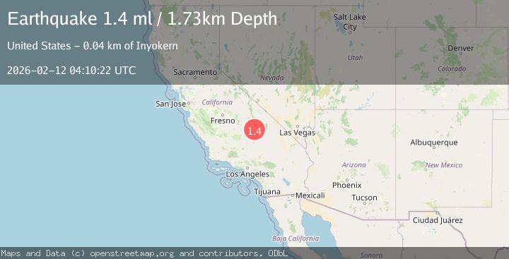
Earthquake 15 km NE of Little Lake, CA
Thu, 12 Feb 2026 04:10:22 GMT
Time6 days ago
Location
36.0213, -117.7772
Depth
1.7 KM
Event Summary
A 1.4 magnitude earthquake struck on 15 km NE of Little Lake, CA, at Thu, 12 Feb 2026 04:10:22 GMT. Depth: 1.73000001907349km. Reviewed by USGS seismologists, this minor quake occurred at a magnitude type of ml.
Magnitude
1.4
ml
Source
USGS
Intensity
-
Agency Reports
1 Sources| Source | Magnitude | Depth | Time |
|---|---|---|---|
| USGSPrimary | 1.4 | 2 km | 6 days ago |
Earthquake Details
AutomaticEvent IDusgs_ci41396216
Tsunami PotentialNo
Magnitude Typeml
Nearest Places
- Coso Hot Springs2.8 km
- Devils Kitchen2.9 km
- Dead End Canyon4.2 km
- Sugarloaf Mountain4.3 km
- Joshua Ridge Facility5.2 km
Comments
Join the discussion about this event.
Latest Earthquakes
1.8Mag
Central Alaska
Time1 hour ago
Depth103.03 km
SourceVYT (Automatic)
1.3Mag
Washington
Time2 hours ago
Depth0.00 km
SourceVYT (Automatic)
1.6Mag
Kenai Peninsula, Alaska
Time2 hours ago
Depth21.36 km
SourceVYT (Automatic)
2.4Mag
South of Java, Indonesia
Time2 hours ago
Depth10.34 km
SourceBMKG
3.1Mag
Near North Coast of West Papua
Time2 hours ago
Depth46.31 km
SourceBMKG
Nearby Earthquakes
3.0Mag
CENTRAL CALIFORNIA
Time4 years ago
Depth2.00 km
SourceNEIR (Automatic)
1.9Mag
Central California
Time6 days ago
Depth3.17 km
SourceVYT (Automatic)
0.9Mag
16 km NE of Little Lake, CA
Time1 week ago
Depth3.73 km
SourceUSGS (Automatic)
1.5Mag
15 km E of Coso Junction, CA
Time2 weeks ago
Depth0.99 km
SourceUSGS (Automatic)
1.7Mag
Central California
Time6 days ago
Depth1.22 km
SourceVYT (Automatic)