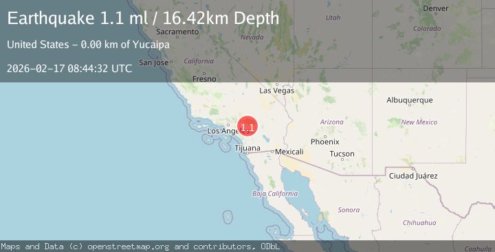
Earthquake 4 km NE of Calimesa, CA
Tue, 17 Feb 2026 08:44:32 GMT
Time2 days ago
Location
34.0062, -117.0208
Depth
16.4 KM
Event Summary
A 1.1 magnitude earthquake struck on 4 km NE of Calimesa, CA, at Tue, 17 Feb 2026 08:44:32 GMT. Depth: 16.4200000762939km. Reviewed by USGS seismologists, this minor quake occurred at a magnitude type of ml.
Magnitude
1.1
ml
Source
USGS
Intensity
-
Agency Reports
1 Sources| Source | Magnitude | Depth | Time |
|---|---|---|---|
| USGSPrimary | 1.1 | 16 km | 2 days ago |
Earthquake Details
AutomaticEvent IDusgs_ci41399216
Tsunami PotentialNo
Magnitude Typeml
Nearest Places
Comments
Join the discussion about this event.
Latest Earthquakes
1.9Mag
British Columbia, Canada
Time19 hours ago
Depth0.98 km
SourceVYT (Automatic)
2.3Mag
Tarapaca, Chile
Time19 hours ago
Depth0.00 km
SourceVYT (Automatic)
2.0Mag
Sumbawa Region, Indonesia
Time19 hours ago
Depth22.95 km
SourceBMKG
1.9Mag
Sweden
Time19 hours ago
Depth0.00 km
SourceVYT (Automatic)
1.6Mag
25 km E of Forsan, Texas
Time19 hours ago
Depth5.85 km
SourceUSGS (Automatic)
Nearby Earthquakes
3.0Mag
SOUTHERN CALIFORNIA
Time1 year ago
Depth25.10 km
SourceNEIC (Automatic)
1.8Mag
Southern California
Time1 week ago
Depth18.43 km
SourceVYT (Automatic)
1.5Mag
Greater Los Angeles area, California
Time6 days ago
Depth12.57 km
SourceVYT (Automatic)
5.3Mag
GREATER LOS ANGELES AREA, CALIF.
Time20 years ago
Depth13.00 km
SourceNEIC (Automatic)
3.0Mag
SOUTHERN CALIFORNIA
Time11 years ago
Depth16.00 km
SourceNEIR (Automatic)