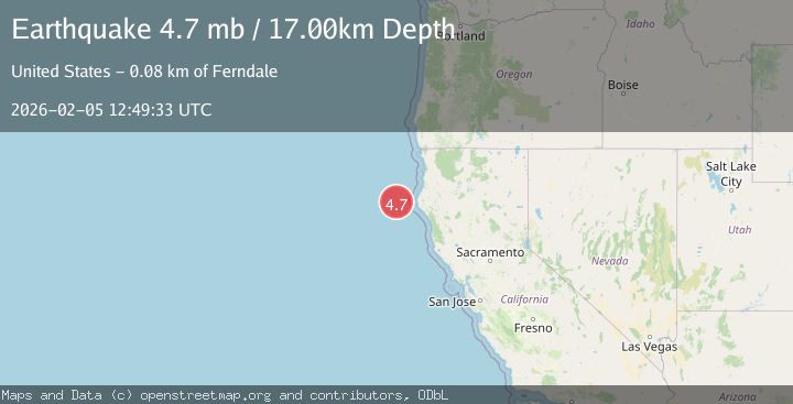
Earthquake 112 km W of Petrolia, CA
Thu, 05 Feb 2026 12:49:28 GMT
Time1 hour ago
Location
40.3980, -125.6087
Depth
2.5 KM
Event Summary
A 4.7 magnitude earthquake struck on 112 km W of Petrolia, CA, at Thu, 05 Feb 2026 12:49:28 GMT. Depth: 2.5km. Reviewed by USGS seismologists, this light quake occurred at a magnitude type of mw.
Magnitude
4.7
mw
Source
USGS
Intensity
-
Agency Reports
2 Sources| Source | Magnitude | Depth | Time |
|---|---|---|---|
| USGSPrimary | 4.7 | 3 km | 1 hour ago |
| EMSC | 4.7 | 17 km | 1 hour ago |
Earthquake Details
ConfirmedEvent IDusgs_nc75308927
Tsunami PotentialNo
Magnitude Typemw
Nearest Places
- Gorda Escarpment37.6 km
- Eel Fan42.4 km
- Bear Valley73.3 km
- Gorda Valley74.1 km
- Gorda Basin74.6 km
Comments
Join the discussion about this event.
Latest Earthquakes
1.2Mag
SWITZERLAND
Time26 minutes ago
Depth6.70 km
SourceETHZ (Automatic)
4.0Mag
EASTERN XIZANG
Time28 minutes ago
Depth10.00 km
SourceNDI (Automatic)
2.2Mag
ALBANIA
Time39 minutes ago
Depth15.00 km
SourceIGEO (Automatic)
2.3Mag
West Papua, Indonesia
Time41 minutes ago
Depth19.97 km
SourceBMKG (Automatic)
2.7Mag
Northern Sumatra, Indonesia
Time41 minutes ago
Depth123.07 km
SourceBMKG (Automatic)
Nearby Earthquakes
2.9Mag
86 km W of Petrolia, CA
Time1 week ago
Depth20.24 km
SourceUSGS (Automatic)
3.9Mag
156 km W of Ferndale, California
Time5 days ago
Depth8.00 km
SourceUSGS (Automatic)
4.5Mag
154 km W of Ferndale, California
Time2 weeks ago
Depth8.00 km
SourceUSGS (Automatic)
2.7Mag
OFFSHORE NORTHERN CALIFORNIA
Time1 week ago
Depth0.20 km
SourceNC (Automatic)
3.4Mag
OFFSHORE NORTHERN CALIFORNIA
Time5 days ago
Depth16.60 km
SourceNC (Automatic)