Earthquake 20 km NNW of Alder Springs, CA
Tue, 10 Feb 2026 04:18:04 GMT
Time1 week ago
Location
39.7998, -122.8503
Depth
7.0 KM
Event Summary
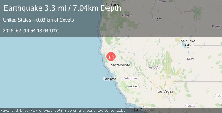
A 3.3 magnitude earthquake struck on 20 km NNW of Alder Springs, CA, at Tue, 10 Feb 2026 04:18:04 GMT. Depth: 7.03999996185303km. Reviewed by USGS seismologists, this minor quake occurred at a magnitude type of ml.
Magnitude
3.3
ml
Source
USGS
Intensity
-
Agency Reports
1 Sources| Source | Magnitude | Depth | Time |
|---|---|---|---|
| USGSPrimary | 3.3 | 7 km | 1 week ago |
Earthquake Details
AutomaticEvent IDusgs_nc75311627
Tsunami PotentialNo
Magnitude Typeml
Nearest Places
- Panther Creek1.3 km
- Harvey Spring Ridge1.8 km
- Board Creek2.4 km
- Harvey Spring Creek2.9 km
- Recer Ridge3.0 km
Comments
Join the discussion about this event.
Latest Earthquakes
0.6Mag
Southern Alaska
Time1 minute ago
Depth0.00 km
SourceVYT (Automatic)
2.3Mag
Antofagasta, Chile
Time2 minutes ago
Depth123.90 km
SourceVYT (Automatic)
2.7Mag
Tarapaca, Chile
Time5 minutes ago
Depth47.00 km
SourceVYT (Automatic)
1.3Mag
Southeastern Alaska
Time6 minutes ago
Depth0.00 km
SourceVYT (Automatic)
1.3Mag
53 km N of Petersville, Alaska
Time6 minutes ago
Depth126.60 km
SourceUSGS (Automatic)
Nearby Earthquakes
3.3Mag
NORTHERN CALIFORNIA
Time1 week ago
Depth7.00 km
SourceNC (Automatic)
2.1Mag
NORTHERN CALIFORNIA
Time1 week ago
Depth10.10 km
SourceNC (Automatic)
2.0Mag
NORTHERN CALIFORNIA
Time4 days ago
Depth13.50 km
SourceNC (Automatic)
2.3Mag
NORTHERN CALIFORNIA
Time1 month ago
Depth-0.70 km
SourceNC (Automatic)
3.0Mag
NORTHERN CALIFORNIA
Time10 years ago
Depth4.00 km
SourceNC (Automatic)