Earthquake 50 km W of Petrolia, CA
Fri, 13 Feb 2026 00:23:44 GMT
Time5 days ago
Location
40.4057, -124.8670
Depth
-0.3 KM
Event Summary
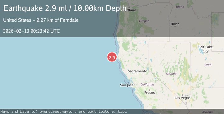
A 3.0 magnitude earthquake struck on 50 km W of Petrolia, CA, at Fri, 13 Feb 2026 00:23:44 GMT. Depth: -0.280000001192093km. Reviewed by USGS seismologists, this minor quake occurred at a magnitude type of ml.
Magnitude
3.0
ml
Source
USGS
Intensity
-
Agency Reports
2 Sources| Source | Magnitude | Depth | Time |
|---|---|---|---|
| USGSPrimary | 3.0 | -0 km | 5 days ago |
| NEIC | 2.9 | 10 km | 5 days ago |
Earthquake Details
AutomaticEvent IDusgs_nc75312947
Tsunami PotentialNo
Magnitude Typeml
Nearest Places
- Bear Valley13.1 km
- Mendocino Canyon22.4 km
- Gorda Escarpment25.8 km
- Blunts Reef Coast Guard Station31.2 km
- Blunts Reef Lightship (historical)31.5 km
Comments
Join the discussion about this event.
Latest Earthquakes
3.7Mag
Tarapaca, Chile
Time2 minutes ago
Depth86.67 km
SourceVYT (Automatic)
2.5Mag
Ceram Sea
Time4 minutes ago
Depth3.27 km
SourceBMKG
2.1Mag
Halmahera, Indonesia
Time7 minutes ago
Depth4.45 km
SourceBMKG
3.4Mag
Talaud Islands, Indonesia
Time10 minutes ago
Depth98.99 km
SourceBMKG
2.1Mag
Flores Region, Indonesia
Time11 minutes ago
Depth165.90 km
SourceBMKG
Nearby Earthquakes
2.6Mag
OFFSHORE NORTHERN CALIFORNIA
Time6 days ago
Depth12.90 km
SourceNC (Automatic)
3.0Mag
OFFSHORE NORTHERN CALIFORNIA
Time1 year ago
Depth19.50 km
SourceNC (Automatic)
5.0Mag
OFFSHORE NORTHERN CALIFORNIA
Time20 years ago
Depth30.00 km
SourceEMSC (Automatic)
3.0Mag
OFFSHORE NORTHERN CALIFORNIA
Time7 months ago
Depth13.30 km
SourceNC (Automatic)
5.9Mag
OFFSHORE NORTHERN CALIFORNIA
Time16 years ago
Depth10.00 km
SourceEMSC (Automatic)