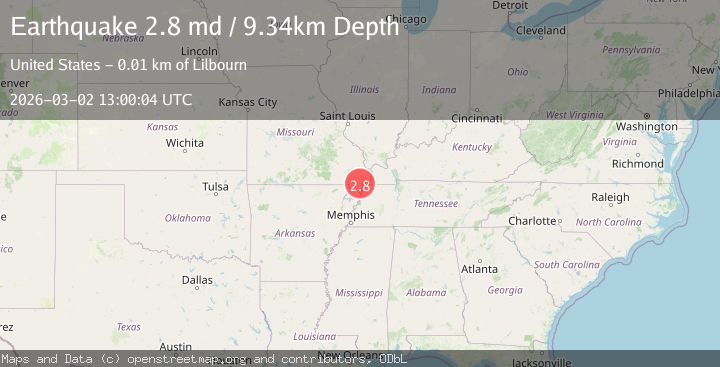
Earthquake 4 km WSW of Howardville, Missouri
Mon, 02 Mar 2026 13:00:04 GMT
Time1 hour ago
Location
36.5498, -89.6435
Depth
8.8 KM
Event Summary
A 2.8 magnitude earthquake struck on 4 km WSW of Howardville, Missouri, at Mon, 02 Mar 2026 13:00:04 GMT. Depth: 8.8100004196167km. Reviewed by USGS seismologists, this minor quake occurred at a magnitude type of md.
Magnitude
2.8
md
Source
USGS
Intensity
-
Agency Reports
1 Sources| Source | Magnitude | Depth | Time |
|---|---|---|---|
| USGSPrimary | 2.8 | 9 km | 1 hour ago |
Earthquake Details
ConfirmedEvent IDusgs_nm60618026
Tsunami PotentialNo
Magnitude Typemd
Nearest Places
- 1.1 km
- 3.5 km
- 3.9 km
- 4.2 km
- 4.3 km
Comments
Join the discussion about this event.
Latest Earthquakes
1.9Mag
19 km SSE of Fern Forest, Hawaii
Time1 hour ago
Depth40.14 km
SourceUSGS (Automatic)
3.1Mag
Arkansas
Time1 hour ago
Depth25.02 km
SourceVYT (Automatic)
1.3Mag
6 km ESE of Temecula, CA
Time1 hour ago
Depth14.28 km
SourceUSGS (Automatic)
3.8Mag
off the west coast of northern Sumatra
Time1 hour ago
Depth26.49 km
SourceVYT (Automatic)
2.7Mag
Caucasus region, Russia
Time1 hour ago
Depth0.00 km
SourceVYT (Automatic)
Nearby Earthquakes
3.0Mag
SOUTHEASTERN MISSOURI
Time10 years ago
Depth9.00 km
SourceNEIR (Automatic)
3.0Mag
SOUTHEASTERN MISSOURI
Time8 years ago
Depth14.00 km
SourceNEIC (Automatic)
2.2Mag
TENNESSEE
Time3 weeks ago
Depth6.00 km
SourceNM (Automatic)
3.0Mag
SOUTHEASTERN MISSOURI
Time10 years ago
Depth9.00 km
SourceNEIR (Automatic)
3.0Mag
TENNESSEE
Time7 years ago
Depth10.00 km
SourceNEIC (Automatic)