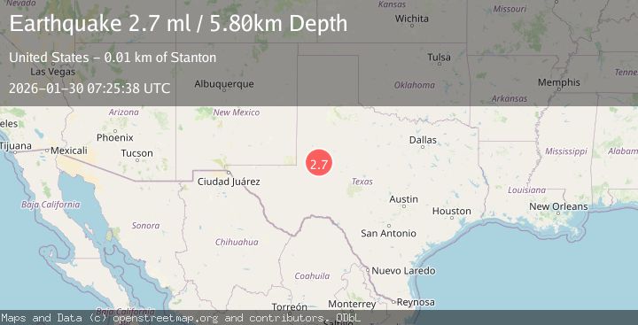
Earthquake 12 km W of Stanton, Texas
Fri, 30 Jan 2026 07:15:14 GMT
Time3 hours ago
Location
32.1070, -101.9230
Depth
4.0 KM
Event Summary
A 2.7 magnitude earthquake struck on 12 km W of Stanton, Texas, at Fri, 30 Jan 2026 07:15:14 GMT. Depth: 4.0489km. Reviewed by USGS seismologists, this minor quake occurred at a magnitude type of ml.
Magnitude
2.7
ml
Source
USGS
Intensity
-
Agency Reports
3 Sources| Source | Magnitude | Depth | Time |
|---|---|---|---|
| USGSPrimary | 2.7 | 4 km | 2 hours ago |
| TX | 2.7 | 4 km | 2 hours ago |
| NEIC | 2.7 | 6 km | 2 hours ago |
Earthquake Details
AutomaticEvent IDusgs_tx2026cbulio
Tsunami PotentialNo
Magnitude Typeml
Nearest Places
- Salt Lake3.7 km
- Mustang Spring4.3 km
- Courtney4.7 km
- Germania5.0 km
- Dix5.5 km
Comments
Join the discussion about this event.
Latest Earthquakes
2.7Mag
Northern Sumatra, Indonesia
Time8 minutes ago
Depth8.31 km
SourceBMKG (Automatic)
2.3Mag
ISLAND OF HAWAII, HAWAII
Time11 minutes ago
Depth30.40 km
SourceHV (Automatic)
2.2Mag
SWITZERLAND
Time17 minutes ago
Depth10.90 km
SourceETHZ (Automatic)
1.4Mag
WESTERN TURKEY
Time18 minutes ago
Depth7.00 km
SourceAFAD (Automatic)
2.1Mag
FRANCE
Time19 minutes ago
Depth5.00 km
SourceReNaSS (Automatic)
Nearby Earthquakes
1.5Mag
12 km W of Stanton, Texas
Time4 days ago
Depth3.73 km
SourceUSGS (Automatic)
1.2Mag
13 km WSW of Stanton, Texas
Time3 days ago
Depth3.46 km
SourceUSGS (Automatic)
1.7Mag
13 km W of Stanton, Texas
Time2 days ago
Depth4.53 km
SourceUSGS (Automatic)
1.2Mag
13 km WSW of Stanton, Texas
Time5 hours ago
Depth4.38 km
SourceUSGS (Automatic)
1.8Mag
13 km WSW of Stanton, Texas
Time2 days ago
Depth4.08 km
SourceUSGS (Automatic)