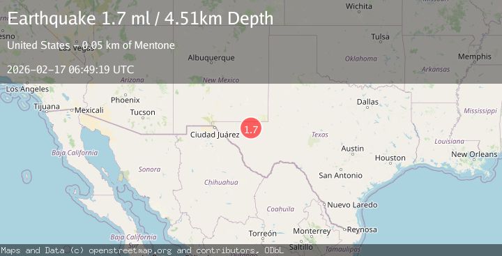
Earthquake 49 km W of Mentone, Texas
Tue, 17 Feb 2026 06:49:19 GMT
Time1 day ago
Location
31.6670, -104.1210
Depth
4.5 KM
Event Summary
A 1.7 magnitude earthquake struck on 49 km W of Mentone, Texas, at Tue, 17 Feb 2026 06:49:19 GMT. Depth: 4.5082km. Reviewed by USGS seismologists, this minor quake occurred at a magnitude type of ml.
Magnitude
1.7
ml
Source
USGS
Intensity
-
Agency Reports
1 Sources| Source | Magnitude | Depth | Time |
|---|---|---|---|
| USGSPrimary | 1.7 | 5 km | 1 day ago |
Earthquake Details
AutomaticEvent IDusgs_tx2026diuscl
Tsunami PotentialNo
Magnitude Typeml
Nearest Places
- Old Michigan Mine3.6 km
- Monument Draw3.8 km
- Salt Spring5.3 km
- Kyle Quarry5.3 km
- Virginia Draw5.6 km
Comments
Join the discussion about this event.
Latest Earthquakes
2.1Mag
Southern Alaska
Time3 minutes ago
Depth67.26 km
SourceVYT (Automatic)
2.2Mag
western Russia
Time6 minutes ago
Depth0.00 km
SourceVYT (Automatic)
1.5Mag
4 km NNW of The Geysers, CA
Time6 minutes ago
Depth-0.27 km
SourceUSGS (Automatic)
1.0Mag
9 km WNW of Two Rivers, Alaska
Time7 minutes ago
Depth5.70 km
SourceUSGS (Automatic)
2.9Mag
NORTHERN CALIFORNIA
Time9 minutes ago
Depth0.10 km
SourceNC (Automatic)
Nearby Earthquakes
1.9Mag
western Texas
Time12 hours ago
Depth5.00 km
SourceVYT (Automatic)
3.8Mag
western Texas
Time1 day ago
Depth0.00 km
SourceVYT (Automatic)
1.7Mag
50 km W of Mentone, Texas
Time22 hours ago
Depth5.67 km
SourceUSGS (Automatic)
1.8Mag
western Texas
Time22 hours ago
Depth5.74 km
SourceVYT (Automatic)
1.7Mag
48 km W of Mentone, Texas
Time8 hours ago
Depth5.91 km
SourceUSGS (Automatic)