Earthquake 242 km ESE of Tadine, New Caledonia
Tue, 20 Jan 2026 23:29:57 GMT
Time2 weeks ago
Location
-22.3293, 170.0691
Depth
10.0 KM
Event Summary
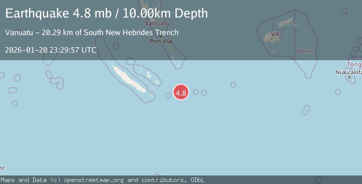
A 4.8 magnitude earthquake struck on 242 km ESE of Tadine, New Caledonia, at Tue, 20 Jan 2026 23:29:57 GMT. Depth: 10km. Reviewed by USGS seismologists, this light quake occurred at a magnitude type of mb.
Magnitude
4.8
mb
Source
USGS
Intensity
-
Agency Reports
1 Sources| Source | Magnitude | Depth | Time |
|---|---|---|---|
| USGSPrimary | 4.8 | 10 km | 2 weeks ago |
Earthquake Details
ConfirmedEvent IDusgs_us7000rqzp
Tsunami PotentialNo
Magnitude Typemb
Nearest Places
- South New Hebrides Trench20.3 km
- New Hebrides Trench20.3 km
- Île Walpole119.3 km
- Île Matthew132.3 km
- Durand Reef149.8 km
Comments
Join the discussion about this event.
Latest Earthquakes
2.4Mag
Minahassa Peninsula, Sulawesi
Time9 minutes ago
Depth86.87 km
SourceBMKG (Automatic)
2.2Mag
ALBANIA
Time18 minutes ago
Depth15.00 km
SourceIGEO (Automatic)
2.4Mag
Northern Sumatra, Indonesia
Time19 minutes ago
Depth64.64 km
SourceBMKG (Automatic)
3.0Mag
PHILIPPINE ISLANDS REGION
Time32 minutes ago
Depth32.00 km
SourcePIVS (Automatic)
1.6Mag
WESTERN TURKEY
Time33 minutes ago
Depth11.80 km
SourceAFAD (Automatic)
Nearby Earthquakes
5.3Mag
242 km ESE of Tadine, New Caledonia
Time2 weeks ago
Depth10.00 km
SourceUSGS
4.8Mag
255 km ESE of Tadine, New Caledonia
Time2 weeks ago
Depth10.00 km
SourceUSGS
4.4Mag
46 km N of Isangel, Vanuatu
Time2 weeks ago
Depth229.76 km
SourceUSGS
4.9Mag
114 km ENE of Luganville, Vanuatu
Time2 weeks ago
Depth10.00 km
SourceUSGS
4.2Mag
SOUTH OF FIJI ISLANDS
Time1 week ago
Depth572.60 km
SourceNEIC (Automatic)