Earthquake 7 km ESE of Lake Roesiger, Washington
Fri, 09 Jan 2026 20:49:16 GMT
Time2 days ago
Location
47.9495, -121.8372
Depth
12.4 KM
Event Summary
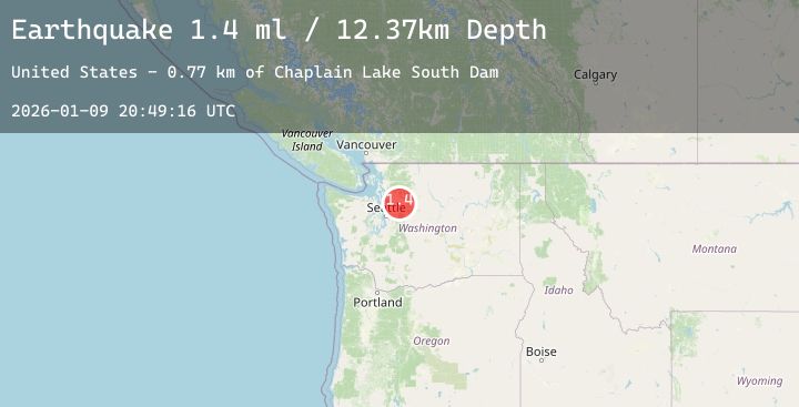
A 1.4 magnitude earthquake struck on 7 km ESE of Lake Roesiger, Washington, at Fri, 09 Jan 2026 20:49:16 GMT. Depth: 12.37km. Reviewed by USGS seismologists, this minor quake occurred at a magnitude type of ml.
Magnitude
1.4
ml
Source
USGS
Intensity
-
Agency Reports
1 Sources| Source | Magnitude | Depth | Time |
|---|---|---|---|
| USGSPrimary | 1.4 | 12 km | 2 days ago |
Earthquake Details
ConfirmedEvent IDusgs_uw62213767
Tsunami PotentialNo
Magnitude Typeml
Nearest Places
- Chaplain Lake South Dam0.7 km
- Everett Water Work Intake0.9 km
- Lake Chaplain1.2 km
- Lost Lake1.4 km
- Ida Lake2.3 km
Comments
Join the discussion about this event.
Latest Earthquakes
2.1Mag
Flores Region, Indonesia
Time2 days ago
Depth95.16 km
SourceBMKG (Automatic)
0.7Mag
10 km WNW of The Geysers, CA
Time2 days ago
Depth2.57 km
SourceUSGS (Automatic)
3.5Mag
Ceram Sea
Time2 days ago
Depth10.00 km
SourceBMKG (Automatic)
2.2Mag
Sumbawa Region, Indonesia
Time2 days ago
Depth20.20 km
SourceBMKG (Automatic)
3.1Mag
Banda Sea
Time2 days ago
Depth180.20 km
SourceBMKG (Automatic)
Nearby Earthquakes
No significant earthquakes nearby recently.