Earthquake Southern Alaska
Thu, 12 Feb 2026 22:54:44 GMT
Time6 days ago
Location
61.4179, -149.9848
Depth
47.0 KM
Event Summary
A 3.7 magnitude earthquake struck on Southern Alaska, at Thu, 12 Feb 2026 22:54:44 GMT. Depth: 46.9970703125km. Reviewed by VYT seismologists, this minor quake occurred at a magnitude type of earthquake.
Magnitude
3.7
earthquake
Source
VYT
Intensity
-
Agency Reports
4 Sources| Source | Magnitude | Depth | Time |
|---|---|---|---|
| VYTPrimary | 3.7 | 47 km | 6 days ago |
| AK | 3.6 | 16 km | 6 days ago |
| USGS | 3.6 | 16 km | 6 days ago |
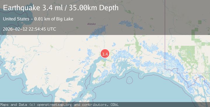
| NEIC | 3.4 | 35 km | 6 days ago |
Earthquake Details
AutomaticEvent IDvyt_13vakp8kkp2rs
Tsunami PotentialNo
Magnitude Typeearthquake
Nearest Places
- Cann Lake2.7 km
- Carpenter Lake3.1 km
- Carpentiers Strip Airport3.4 km
- Jewell Lake4.1 km
- Central Matanuska - Susitna Fire Department Station 644.4 km
Comments
Join the discussion about this event.
Latest Earthquakes
3.4Mag
San Juan, Argentina
Time7 minutes ago
Depth10.00 km
SourceVYT (Automatic)
3.0Mag
Potosi, Bolivia
Time10 minutes ago
Depth269.04 km
SourceVYT (Automatic)
2.4Mag
Central Alaska
Time12 minutes ago
Depth0.24 km
SourceVYT (Automatic)
3.7Mag
Seram, Indonesia
Time12 minutes ago
Depth0.00 km
SourceVYT (Automatic)
3.9Mag
North of Halmahera, Indonesia
Time13 minutes ago
Depth14.71 km
SourceBMKG
Nearby Earthquakes
3.0Mag
SOUTHERN ALASKA
Time7 years ago
Depth35.00 km
SourceNEIC (Automatic)
4.0Mag
SOUTHERN ALASKA
Time7 years ago
Depth41.00 km
SourceNEIR (Automatic)
3.0Mag
SOUTHERN ALASKA
Time6 years ago
Depth20.00 km
SourceNEIR (Automatic)
5.0Mag
SOUTHERN ALASKA
Time7 years ago
Depth47.00 km
SourceEMSC (Automatic)
4.0Mag
SOUTHERN ALASKA
Time7 years ago
Depth22.00 km
SourceNEIC (Automatic)