Earthquake northern Sumatra, Indonesia
Wed, 11 Feb 2026 15:23:08 GMT
Time1 week ago
Location
4.9606, 96.0829
Depth
159.8 KM
Event Summary
A 3.9 magnitude earthquake struck on northern Sumatra, Indonesia, at Wed, 11 Feb 2026 15:23:08 GMT. Depth: 159.7900390625km. Reviewed by VYT seismologists, this minor quake occurred at a magnitude type of earthquake.
Magnitude
3.9
earthquake
Source
VYT
Intensity
-
Agency Reports
2 Sources| Source | Magnitude | Depth | Time |
|---|---|---|---|
| VYTPrimary | 3.9 | 160 km | 1 week ago |
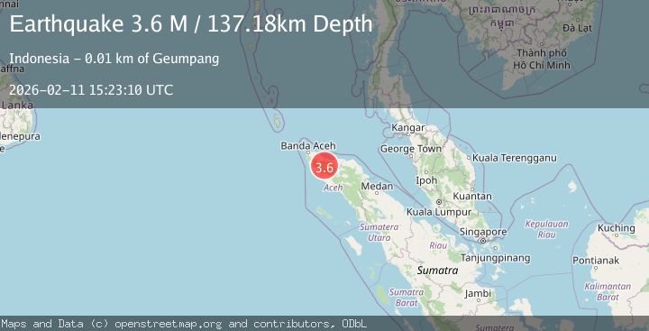
| BMKG | 3.6 | 137 km | 1 week ago |
Earthquake Details
AutomaticEvent IDvyt_1a20igp6920w9
Tsunami PotentialNo
Magnitude Typeearthquake
Nearest Places
- Gunung Pucuk Leumieh0.4 km
- Gunung Pucuk Jaleuem3.2 km
- Alue Kuala Lee4.0 km
- Krueng Jaleuem4.5 km
- Gunung Kalek4.5 km
Comments
Join the discussion about this event.
Latest Earthquakes
1.0Mag
Southeastern Alaska
Time2 minutes ago
Depth0.00 km
SourceVYT (Automatic)
3.5Mag
COOK STRAIT, NEW ZEALAND
Time3 minutes ago
Depth75.30 km
SourceGNS (Automatic)
2.4Mag
Seram, Indonesia
Time5 minutes ago
Depth18.42 km
SourceBMKG
2.6Mag
West Papua Region, Indonesia
Time7 minutes ago
Depth17.35 km
SourceBMKG
2.8Mag
Antofagasta, Chile
Time11 minutes ago
Depth0.00 km
SourceVYT (Automatic)
Nearby Earthquakes
2.6Mag
NORTHERN SUMATRA, INDONESIA
Time1 month ago
Depth6.00 km
SourceBMKG (Automatic)
3.0Mag
NORTHERN SUMATRA, INDONESIA
Time5 years ago
Depth10.00 km
SourceDJA (Automatic)
2.1Mag
Northern Sumatra, Indonesia
Time3 weeks ago
Depth4.51 km
SourceBMKG (Automatic)
3.0Mag
NORTHERN SUMATRA, INDONESIA
Time3 years ago
Depth10.00 km
SourceDJA (Automatic)
3.0Mag
NORTHERN SUMATRA, INDONESIA
Time5 years ago
Depth21.00 km
SourceDJA (Automatic)