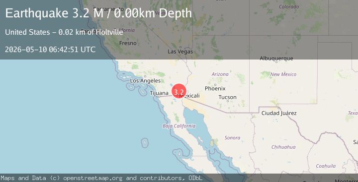
Earthquake California-Baja California border region
Sun, 10 May 2026 06:42:51 GMT
Low Quality Data Warning
This earthquake may be wrong/incorrect, it is recommended not to spread this information because there is a possibility that further updates are needed for data accuracy.
Time14 hours ago
Location
32.9586, -115.2371
Depth
0.0 KM
Event Summary
A 3.2 magnitude earthquake struck on California-Baja California border region, at Sun, 10 May 2026 06:42:51 GMT. Depth: 0km. Reviewed by VYT seismologists, this minor quake occurred at a magnitude type of M.
Magnitude
3.2
M
Source
VYT
Intensity
II
Agency Reports
3 Sources| Source | Magnitude | Depth | Time |
|---|---|---|---|
| VYTPrimary | 3.2 | 0 km | 14 hours ago |
| SCSN | 3.2 | 13 km | 14 hours ago |
| USGS | 3.2 | 13 km | 14 hours ago |
Earthquake Details
AutomaticEvent IDvyt_1aeboj4cn8ohh
QualityD
Tsunami PotentialNo
Magnitude TypeM
Last Update14 hours ago
Used Stations71
Total Stations13
Nearest Places
Possibly felt by: 152.9K
- 21.2 km6.4K people
- IIBrawley27.4 km25.9K people
- 31.8 km7.4K people
- IIImperial33.4 km17.1K people
- 35.6 km44K people
- 36.9 km2.3K people
- IIHeber37.3 km4.3K people
- 39.6 km40.1K people
- 39.6 km2K people
- 40.0 km1.1K people
- 40.6 km1.1K people
- 40.9 km1K people
- 41.6 km1.6K people
- 42.0 km1M people
- 43.9 km2.5K people
- 44.9 km15.2K people
- 45.8 km2.5K people
- 46.2 km1.7K people
- 46.9 km2.5K people
- 48.1 km29.3K people
- 49.0 km4.2K people
- 49.6 km5.3K people
- 52.8 km1K people
- 53.2 km12.6K people
- 53.4 km1.7K people
- 55.2 km4.9K people
- 55.3 km3.1K people
- 56.4 km2.3K people
- 57.8 km5.1K people
- 59.1 km1.5K people
- 60.1 km4.2K people
- 60.3 km1.6K people
- 60.5 km1.1K people
- 61.1 km3.7K people
- IYuma62.8 km94.1K people
- 63.2 km1.5K people
- 63.7 km15K people
Felt Reports0
Did you feel this earthquake? Report it to help others.
No reports yet
Be the first to report this earthquake!
Latest Earthquakes
Loading...
Nearby Earthquakes
2.3Mag
California-Baja California border region
Time14 hours ago
Depth15.14 km
SourceVYT (Automatic)
3.1Mag
SOUTHERN CALIFORNIA
Time14 hours ago
Depth12.50 km
SourceSCSN (Automatic)
3.6Mag
Sonora, Mexico
Time14 hours ago
Depth0.12 km
SourceVYT (Automatic)
1.9Mag
2 km SSW of Brawley, CA
Time14 hours ago
Depth11.32 km
SourceUSGS (Automatic)
1.9Mag
1 km SSW of Brawley, CA
Time14 hours ago
Depth7.94 km
SourceUSGS (Automatic)