Earthquake northern Sumatra, Indonesia
Sat, 21 Feb 2026 21:05:08 GMT
Time1 hour ago
Location
4.2150, 97.5678
Depth
0.0 KM
Event Summary
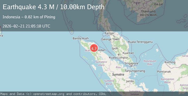
A 4.3 magnitude earthquake struck on northern Sumatra, Indonesia, at Sat, 21 Feb 2026 21:05:08 GMT. Depth: 0km. Reviewed by VYT seismologists, this light quake occurred at a magnitude type of earthquake.
Magnitude
4.3
earthquake
Source
VYT
Intensity
-
Agency Reports
1 Sources| Source | Magnitude | Depth | Time |
|---|---|---|---|
| VYTPrimary | 4.3 | 0 km | 1 hour ago |
Earthquake Details
AutomaticEvent IDvyt_1e8flxqj1bsp5
Tsunami PotentialNo
Magnitude Typeearthquake
Nearest Places
- 1.4 km
- 1.6 km
- 2.4 km
- 2.5 km
- 3.7 km
Comments
Join the discussion about this event.
Latest Earthquakes
0.9Mag
7 km NW of The Geysers, CA
Time1 hour ago
Depth2.85 km
SourceUSGS (Automatic)
2.5Mag
near the coast of southern Peru
Time1 hour ago
Depth0.61 km
SourceVYT (Automatic)
3.0Mag
Southern Alaska
Time1 hour ago
Depth0.00 km
SourceVYT (Automatic)
3.0Mag
ANTOFAGASTA, CHILE
Time1 hour ago
Depth217.80 km
SourceCSN (Automatic)
0.8Mag
10 km NW of The Geysers, CA
Time1 hour ago
Depth1.37 km
SourceUSGS (Automatic)
Nearby Earthquakes
4.0Mag
Northern Sumatra, Indonesia
Time1 week ago
Depth10.00 km
SourceBMKG
2.7Mag
Northern Sumatra, Indonesia
Time1 week ago
Depth1.00 km
SourceBMKG
2.8Mag
NORTHERN SUMATRA, INDONESIA
Time1 week ago
Depth5.00 km
SourceBMKG (Automatic)
3.0Mag
NORTHERN SUMATRA, INDONESIA
Time4 months ago
Depth10.00 km
SourceBMKG (Automatic)
3.6Mag
NORTHERN SUMATRA, INDONESIA
Time1 month ago
Depth0.00 km
SourceBMKG (Automatic)