Earthquake Southern California
Mon, 16 Feb 2026 13:38:12 GMT
Time3 days ago
Location
33.9559, -116.0117
Depth
3.9 KM
Event Summary
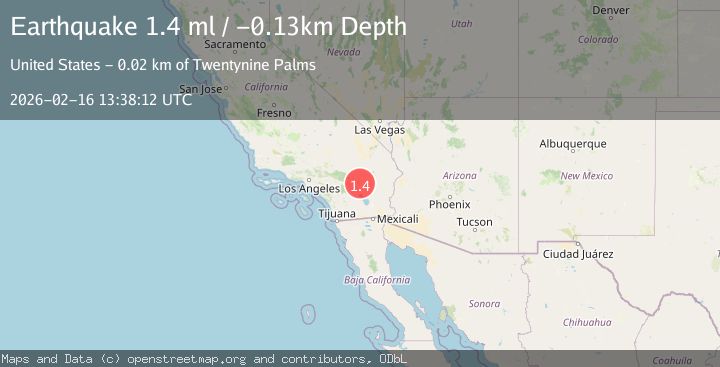
A 1.7 magnitude earthquake struck on Southern California, at Mon, 16 Feb 2026 13:38:12 GMT. Depth: 3.90625km. Reviewed by VYT seismologists, this minor quake occurred at a magnitude type of earthquake.
Magnitude
1.7
earthquake
Source
VYT
Intensity
-
Agency Reports
2 Sources| Source | Magnitude | Depth | Time |
|---|---|---|---|
| VYTPrimary | 1.7 | 4 km | 3 days ago |
| USGS | 1.4 | -0 km | 3 days ago |
Earthquake Details
AutomaticEvent IDvyt_1g0rd533ki320
Tsunami PotentialNo
Magnitude Typeearthquake
Nearest Places
- Stirrup Tank0.6 km
- Hidden Tank0.8 km
- White Tank3.3 km
- Hexahedron Mine3.3 km
- White Tank Campground3.4 km
Comments
Join the discussion about this event.
Latest Earthquakes
0.6Mag
Southern Alaska
Time21 hours ago
Depth0.00 km
SourceVYT (Automatic)
2.3Mag
Antofagasta, Chile
Time21 hours ago
Depth123.90 km
SourceVYT (Automatic)
2.7Mag
Tarapaca, Chile
Time22 hours ago
Depth47.00 km
SourceVYT (Automatic)
1.3Mag
Southeastern Alaska
Time22 hours ago
Depth0.00 km
SourceVYT (Automatic)
1.3Mag
53 km N of Petersville, Alaska
Time22 hours ago
Depth126.60 km
SourceUSGS (Automatic)
Nearby Earthquakes
1.1Mag
23 km SSE of Twentynine Palms, CA
Time4 days ago
Depth1.15 km
SourceUSGS (Automatic)
2.1Mag
Southern California
Time1 week ago
Depth27.22 km
SourceVYT (Automatic)
1.8Mag
Southern California
Time1 week ago
Depth26.61 km
SourceVYT (Automatic)
1.2Mag
21 km NNE of Indio, CA
Time3 weeks ago
Depth5.65 km
SourceUSGS (Automatic)
1.0Mag
21 km NNE of Indio, CA
Time5 days ago
Depth6.52 km
SourceUSGS (Automatic)