Earthquake Halmahera, Indonesia
Fri, 13 Feb 2026 11:41:20 GMT
Time5 days ago
Location
0.8600, 127.0353
Depth
728.5 KM
Event Summary
A 4.7 magnitude earthquake struck on Halmahera, Indonesia, at Fri, 13 Feb 2026 11:41:20 GMT. Depth: 728.515625km. Reviewed by VYT seismologists, this light quake occurred at a magnitude type of earthquake.
Magnitude
4.7
earthquake
Source
VYT
Intensity
-
Agency Reports
2 Sources| Source | Magnitude | Depth | Time |
|---|---|---|---|
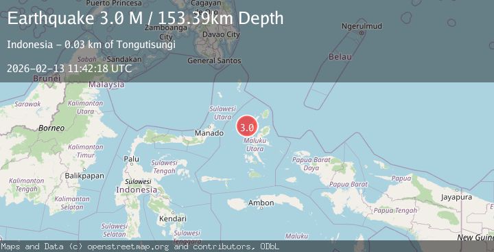
| VYTPrimary | 4.7 | 729 km | 5 days ago |
| BMKG | 3.0 | 153 km | 5 days ago |
Earthquake Details
AutomaticEvent IDvyt_1s2stb8sjiqwo
Tsunami PotentialNo
Magnitude Typeearthquake
Nearest Places
- Nguai Pilatu29.2 km
- Togafo29.3 km
- Loto29.4 km
- Tanjung Taduma29.5 km
- Banedinga29.6 km
Comments
Join the discussion about this event.
Latest Earthquakes
1.3Mag
19 km NNW of Borrego Springs, CA
Time3 hours ago
Depth9.65 km
SourceUSGS (Automatic)
2.0Mag
Sweden
Time3 hours ago
Depth10.00 km
SourceVYT (Automatic)
1.9Mag
12 km S of Volcano, Hawaii
Time3 hours ago
Depth2.42 km
SourceUSGS (Automatic)
2.2Mag
Java, Indonesia
Time3 hours ago
Depth10.00 km
SourceBMKG
2.5Mag
Finland-Russia border region
Time3 hours ago
Depth0.00 km
SourceVYT (Automatic)
Nearby Earthquakes
2.7Mag
HALMAHERA, INDONESIA
Time1 month ago
Depth10.00 km
SourceBMKG (Automatic)
3.0Mag
MOLUCCA SEA
Time11 months ago
Depth14.00 km
SourceBMKG (Automatic)
3.0Mag
MOLUCCA SEA
Time2 years ago
Depth17.00 km
SourceDJA (Automatic)
2.5Mag
Northern Molucca Sea
Time20 hours ago
Depth10.00 km
SourceBMKG
5.3Mag
MOLUCCA SEA
Time19 years ago
Depth73.00 km
SourceEMSC (Automatic)