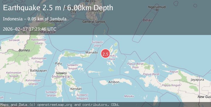
Earthquake Northern Molucca Sea
Tue, 17 Feb 2026 17:23:46 GMT
Time20 hours ago
Location
0.9893, 126.9726
Depth
10.0 KM
Event Summary
A 2.4 magnitude earthquake struck on Northern Molucca Sea, at Tue, 17 Feb 2026 17:23:46 GMT. Depth: 10km. Reviewed by BMKG seismologists, this minor quake occurred at a magnitude type of M.
Magnitude
2.4
M
Source
BMKG
Intensity
-
Agency Reports
1 Sources| Source | Magnitude | Depth | Time |
|---|---|---|---|
| BMKGPrimary | 2.4 | 10 km | 20 hours ago |
Earthquake Details
ManualEvent IDbmg2026djfb
Tsunami PotentialNo
Magnitude TypeM
Nearest Places
- Tanjung Kao Cina38.1 km
- Kao Cina38.4 km
- Pulau Maka38.4 km
- Kelurahan Tomajiko38.8 km
- Kota Ternate38.9 km
Comments
Join the discussion about this event.
Latest Earthquakes
2.2Mag
45 km SW of Karluk, Alaska
Time20 hours ago
Depth60.60 km
SourceUSGS (Automatic)
2.6Mag
Antofagasta, Chile
Time20 hours ago
Depth0.00 km
SourceVYT (Automatic)
2.3Mag
Poland
Time20 hours ago
Depth0.00 km
SourceVYT (Automatic)
4.9Mag
Minahasa, Sulawesi, Indonesia
Time20 hours ago
Depth93.63 km
SourceVYT (Automatic)
3.5Mag
PERU-ECUADOR BORDER REGION
Time20 hours ago
Depth64.00 km
SourceQUI (Automatic)
Nearby Earthquakes
5.3Mag
MOLUCCA SEA
Time4 years ago
Depth10.00 km
SourceEMSC (Automatic)
3.0Mag
MOLUCCA SEA
Time4 years ago
Depth21.00 km
SourceDJA (Automatic)
2.7Mag
Northern Molucca Sea
Time1 week ago
Depth12.48 km
SourceBMKG (Automatic)
3.0Mag
MOLUCCA SEA
Time2 years ago
Depth17.00 km
SourceDJA (Automatic)
3.0Mag
MOLUCCA SEA
Time2 years ago
Depth53.00 km
SourceBMKG (Automatic)