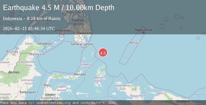
Earthquake north of Halmahera, Indonesia
Sun, 15 Feb 2026 01:46:39 GMT
Time3 days ago
Location
4.1534, 128.1044
Depth
10.0 KM
Event Summary
A 4.5 magnitude earthquake struck on north of Halmahera, Indonesia, at Sun, 15 Feb 2026 01:46:39 GMT. Depth: 10km. Reviewed by VYT seismologists, this light quake occurred at a magnitude type of earthquake.
Magnitude
4.5
earthquake
Source
VYT
Intensity
-
Agency Reports
2 Sources| Source | Magnitude | Depth | Time |
|---|---|---|---|
| VYTPrimary | 3.4 | 10 km | 3 days ago |
| BMKG | 4.5 | 10 km | 3 days ago |
Earthquake Details
AutomaticEvent IDvyt_1tfshtii3qvve
Tsunami PotentialNo
Magnitude Typeearthquake
Nearest Places
- Snellius Ridge20.6 km
- Talaud Trough78.2 km
- Pulau Karis116.2 km
- Pulau Kakorotan117.2 km
- Desa Kakorotan117.3 km
Comments
Join the discussion about this event.
Latest Earthquakes
2.0Mag
66 km W of Akhiok, Alaska
Time5 hours ago
Depth11.80 km
SourceUSGS (Automatic)
1.6Mag
Alaska Peninsula
Time5 hours ago
Depth0.00 km
SourceVYT (Automatic)
1.0Mag
8 km NW of The Geysers, CA
Time5 hours ago
Depth1.53 km
SourceUSGS (Automatic)
2.7Mag
Java, Indonesia
Time5 hours ago
Depth40.72 km
SourceBMKG
1.1Mag
WESTERN TURKEY
Time5 hours ago
Depth7.50 km
SourceAFAD (Automatic)
Nearby Earthquakes
5.8Mag
NORTH OF HALMAHERA, INDONESIA
Time21 years ago
Depth33.00 km
SourceEMSC (Automatic)
5.0Mag
NORTH OF HALMAHERA, INDONESIA
Time12 years ago
Depth70.00 km
SourceEMSC (Automatic)
3.9Mag
North of Halmahera, Indonesia
Time3 days ago
Depth9.91 km
SourceBMKG
6.0Mag
NORTH OF HALMAHERA, INDONESIA
Time4 years ago
Depth160.00 km
SourceEMSC (Automatic)
4.0Mag
North of Halmahera, Indonesia
Time4 days ago
Depth10.00 km
SourceBMKG