Earthquake southern Sumatra, Indonesia
Fri, 13 Feb 2026 18:39:30 GMT
Time5 days ago
Location
-5.2974, 104.5262
Depth
7.9 KM
Event Summary
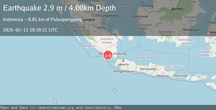
A 2.9 magnitude earthquake struck on southern Sumatra, Indonesia, at Fri, 13 Feb 2026 18:39:30 GMT. Depth: 7.9345703125km. Reviewed by VYT seismologists, this minor quake occurred at a magnitude type of earthquake.
Magnitude
2.9
earthquake
Source
VYT
Intensity
-
Agency Reports
2 Sources| Source | Magnitude | Depth | Time |
|---|---|---|---|
| VYTPrimary | 2.9 | 8 km | 5 days ago |
| BMKG | 2.9 | 4 km | 5 days ago |
Earthquake Details
AutomaticEvent IDvyt_1tyh4u59jkz0p
Tsunami PotentialNo
Magnitude Typeearthquake
Nearest Places
- Desa Ngarip1.9 km
- Mujirukun2.8 km
- Pondoksarah3.0 km
- Ngarip3.0 km
- Desa Penantian Ulu Belu3.0 km
Comments
Join the discussion about this event.
Latest Earthquakes
3.4Mag
Flores region, Indonesia
Time14 hours ago
Depth22.83 km
SourceVYT (Automatic)
2.4Mag
Sumbawa Region, Indonesia
Time14 hours ago
Depth10.00 km
SourceBMKG
1.3Mag
3 km SSW of Cobb, CA
Time14 hours ago
Depth0.36 km
SourceUSGS (Automatic)
1.8Mag
Southern California
Time14 hours ago
Depth13.43 km
SourceVYT (Automatic)
1.9Mag
Southern Alaska
Time14 hours ago
Depth0.00 km
SourceVYT (Automatic)
Nearby Earthquakes
2.3Mag
Southern Sumatra, Indonesia
Time2 weeks ago
Depth15.95 km
SourceBMKG (Automatic)
2.0Mag
Southern Sumatra, Indonesia
Time5 days ago
Depth4.27 km
SourceBMKG
2.5Mag
SOUTHERN SUMATRA, INDONESIA
Time1 month ago
Depth6.00 km
SourceBMKG (Automatic)
2.0Mag
Southern Sumatra, Indonesia
Time2 weeks ago
Depth10.00 km
SourceBMKG (Automatic)
2.0Mag
Southern Sumatra, Indonesia
Time4 days ago
Depth10.07 km
SourceBMKG