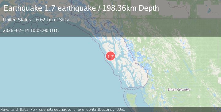
Earthquake Southeastern Alaska
Sat, 14 Feb 2026 10:05:00 GMT
Time1 week ago
Location
57.2073, -135.3617
Depth
198.4 KM
Event Summary
A 1.7 magnitude earthquake struck on Southeastern Alaska, at Sat, 14 Feb 2026 10:05:00 GMT. Depth: 198.3642578125km. Reviewed by VYT seismologists, this minor quake occurred at a magnitude type of earthquake.
Magnitude
1.7
earthquake
Source
VYT
Intensity
-
Agency Reports
1 Sources| Source | Magnitude | Depth | Time |
|---|---|---|---|
| VYTPrimary | 1.7 | 198 km | 1 week ago |
Earthquake Details
AutomaticEvent IDvyt_1uzcbpt5vyg75
Tsunami PotentialNo
Magnitude Typeearthquake
Nearest Places
- 1.8 km
- 2.5 km
- 4.1 km
- 4.3 km
- 4.5 km
Comments
Join the discussion about this event.
Latest Earthquakes
1.8Mag
Antofagasta, Chile
Time19 hours ago
Depth0.00 km
SourceVYT (Automatic)
3.2Mag
Sulawesi, Indonesia
Time19 hours ago
Depth9.64 km
SourceVYT (Automatic)
3.4Mag
WESTERN TURKEY
Time19 hours ago
Depth9.90 km
SourceAFAD (Automatic)
2.4Mag
Sumbawa Region, Indonesia
Time19 hours ago
Depth24.39 km
SourceBMKG
3.2Mag
Southern Alaska
Time19 hours ago
Depth52.61 km
SourceVYT (Automatic)
Nearby Earthquakes
2.5Mag
19 km WNW of Sitka, Alaska
Time2 weeks ago
Depth5.50 km
SourceUSGS (Automatic)
3.0Mag
SOUTHEASTERN ALASKA
Time6 years ago
Depth5.00 km
SourceNEIR (Automatic)
2.2Mag
SOUTHEASTERN ALASKA
Time1 month ago
Depth2.80 km
SourceAV (Automatic)
2.3Mag
SOUTHEASTERN ALASKA
Time1 month ago
Depth13.40 km
SourceAV (Automatic)
5.9Mag
SOUTHEASTERN ALASKA
Time2 years ago
Depth10.00 km
SourceEMSC (Automatic)