Earthquake Timor region, Indonesia
Wed, 11 Feb 2026 06:27:30 GMT
Time1 week ago
Location
-9.4404, 123.6816
Depth
2.0 KM
Event Summary
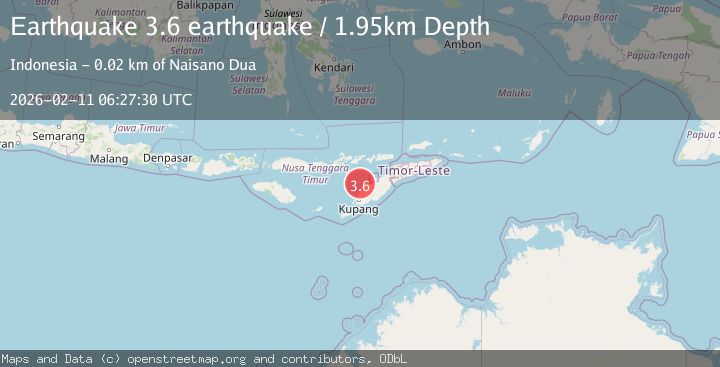
A 3.6 magnitude earthquake struck on Timor region, Indonesia, at Wed, 11 Feb 2026 06:27:30 GMT. Depth: 1.953125km. Reviewed by VYT seismologists, this minor quake occurred at a magnitude type of earthquake.
Magnitude
3.6
earthquake
Source
VYT
Intensity
-
Agency Reports
2 Sources| Source | Magnitude | Depth | Time |
|---|---|---|---|
| VYTPrimary | 3.6 | 2 km | 1 week ago |
| BMKG | 3.0 | 29 km | 1 week ago |
Earthquake Details
AutomaticEvent IDvyt_1vb949o7tkpn3
Tsunami PotentialNo
Magnitude Typeearthquake
Nearest Places
- Nono Oelpasi14.3 km
- Kapuktulis14.4 km
- Tanjung Gumuk14.6 km
- Nono Pakun14.7 km
- Nono Tliman14.9 km
Comments
Join the discussion about this event.
Latest Earthquakes
2.4Mag
Sulawesi, Indonesia
Time8 minutes ago
Depth4.26 km
SourceBMKG
2.2Mag
Northern Sumatra, Indonesia
Time11 minutes ago
Depth8.25 km
SourceBMKG
2.5Mag
CRETE, GREECE
Time18 minutes ago
Depth17.50 km
SourceNOA (Automatic)
2.5Mag
Tarapaca, Chile
Time22 minutes ago
Depth112.55 km
SourceVYT (Automatic)
2.0Mag
ALBANIA
Time23 minutes ago
Depth15.00 km
SourceIGEO (Automatic)
Nearby Earthquakes
4.0Mag
TIMOR REGION, INDONESIA
Time1 year ago
Depth10.00 km
SourceBMKG (Automatic)
5.2Mag
TIMOR REGION, INDONESIA
Time18 years ago
Depth72.00 km
SourceGFZ (Automatic)
2.6Mag
TIMOR REGION, INDONESIA
Time1 month ago
Depth63.00 km
SourceBMKG (Automatic)
2.6Mag
Timor Region
Time1 week ago
Depth16.69 km
SourceBMKG (Automatic)
3.0Mag
TIMOR REGION, INDONESIA
Time3 years ago
Depth27.00 km
SourceDJA (Automatic)