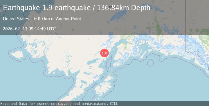
Earthquake Southern Alaska
Fri, 13 Feb 2026 09:14:49 GMT
Time5 days ago
Location
60.2032, -153.2544
Depth
136.8 KM
Event Summary
A 1.9 magnitude earthquake struck on Southern Alaska, at Fri, 13 Feb 2026 09:14:49 GMT. Depth: 136.8408203125km. Reviewed by VYT seismologists, this minor quake occurred at a magnitude type of earthquake.
Magnitude
1.9
earthquake
Source
VYT
Intensity
-
Agency Reports
1 Sources| Source | Magnitude | Depth | Time |
|---|---|---|---|
| VYTPrimary | 1.9 | 137 km | 5 days ago |
Earthquake Details
AutomaticEvent IDvyt_2961o43buvci2
Tsunami PotentialNo
Magnitude Typeearthquake
Nearest Places
- Tuxedni Glacier12.1 km
- Tuxedni Glacier13.7 km
- Tongue Glacier15.5 km
- Johnson Glacier16.3 km
- Mount Nick17.7 km
Comments
Join the discussion about this event.
Latest Earthquakes
1.7Mag
western Texas
Time5 minutes ago
Depth3.42 km
SourceVYT (Automatic)
3.8Mag
Seram, Indonesia
Time7 minutes ago
Depth0.00 km
SourceVYT (Automatic)
1.6Mag
54 km WNW of Toyah, Texas
Time13 minutes ago
Depth0.00 km
SourceUSGS (Automatic)
2.2Mag
West Papua Region, Indonesia
Time14 minutes ago
Depth26.69 km
SourceBMKG
1.2Mag
WESTERN TURKEY
Time15 minutes ago
Depth7.00 km
SourceAFAD (Automatic)
Nearby Earthquakes
3.0Mag
SOUTHERN ALASKA
Time4 years ago
Depth141.00 km
SourceNEIC (Automatic)
2.5Mag
SOUTHERN ALASKA
Time1 month ago
Depth145.50 km
SourceNEIC (Automatic)
1.1Mag
Southern Alaska
Time5 days ago
Depth0.00 km
SourceVYT (Automatic)
3.0Mag
SOUTHERN ALASKA
Time5 years ago
Depth137.00 km
SourceNEIC (Automatic)
3.0Mag
SOUTHERN ALASKA
Time12 years ago
Depth138.00 km
SourceNEIR (Automatic)