Earthquake Southeastern Alaska
Fri, 13 Feb 2026 10:09:25 GMT
Time5 days ago
Location
60.5201, -139.8871
Depth
0.1 KM
Event Summary
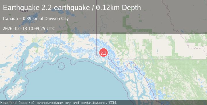
A 2.2 magnitude earthquake struck on Southeastern Alaska, at Fri, 13 Feb 2026 10:09:25 GMT. Depth: 0.1220703125km. Reviewed by VYT seismologists, this minor quake occurred at a magnitude type of earthquake.
Magnitude
2.2
earthquake
Source
VYT
Intensity
-
Agency Reports
1 Sources| Source | Magnitude | Depth | Time |
|---|---|---|---|
| VYTPrimary | 2.2 | 0 km | 5 days ago |
Earthquake Details
AutomaticEvent IDvyt_2g3vxkjpz029a
Tsunami PotentialNo
Magnitude Typeearthquake
Nearest Places
- Marker Lake5.6 km
- Mount King George5.6 km
- Mount Queen Mary14.9 km
- McArthur Peak20.2 km
- Mount Vancouver20.7 km
Comments
Join the discussion about this event.
Latest Earthquakes
3.6Mag
Fox Islands, Aleutian Islands, Alaska
Time2 minutes ago
Depth28.81 km
SourceVYT (Automatic)
1.3Mag
Washington
Time3 minutes ago
Depth0.00 km
SourceVYT (Automatic)
2.0Mag
Antofagasta, Chile
Time4 minutes ago
Depth28.32 km
SourceVYT (Automatic)
1.2Mag
Central Alaska
Time4 minutes ago
Depth0.00 km
SourceVYT (Automatic)
2.1Mag
Sulawesi, Indonesia
Time6 minutes ago
Depth7.10 km
SourceBMKG
Nearby Earthquakes
2.6Mag
SOUTHERN YUKON TERRITORY, CANADA
Time1 week ago
Depth5.00 km
SourceNEIC (Automatic)
2.5Mag
SOUTHERN YUKON TERRITORY, CANADA
Time3 weeks ago
Depth5.00 km
SourceCN (Automatic)
2.6Mag
SOUTHERN YUKON TERRITORY, CANADA
Time1 month ago
Depth5.00 km
SourceNEIC (Automatic)
1.8Mag
Southeastern Alaska
Time6 days ago
Depth1.71 km
SourceVYT (Automatic)
4.0Mag
SOUTHERN YUKON TERRITORY, CANADA
Time2 months ago
Depth5.00 km
SourceNEIC (Automatic)