Earthquake Flores region, Indonesia
Tue, 17 Feb 2026 17:18:41 GMT
Time19 hours ago
Location
-8.2828, 121.0493
Depth
26.6 KM
Event Summary
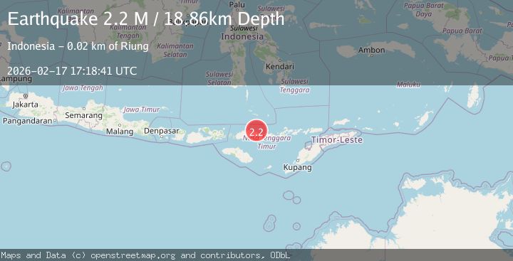
A 2.1 magnitude earthquake struck on Flores region, Indonesia, at Tue, 17 Feb 2026 17:18:41 GMT. Depth: 26.611328125km. Reviewed by VYT seismologists, this minor quake occurred at a magnitude type of earthquake.
Magnitude
2.1
earthquake
Source
VYT
Intensity
-
Agency Reports
1 Sources| Source | Magnitude | Depth | Time |
|---|---|---|---|
| VYTPrimary | 2.1 | 27 km | 19 hours ago |
Earthquake Details
AutomaticEvent IDvyt_2gia972yaoasv
Tsunami PotentialNo
Magnitude Typeearthquake
Nearest Places
- Nunsa Bakau11.0 km
- Tanjung Toropadang11.1 km
- Pulau Kolong11.3 km
- Tanjung Lambacah11.6 km
- Teluk Lohoembo11.6 km
Comments
Join the discussion about this event.
Latest Earthquakes
2.1Mag
Sumbawa Region, Indonesia
Time19 hours ago
Depth26.24 km
SourceBMKG
3.0Mag
Kenai Peninsula, Alaska
Time19 hours ago
Depth57.62 km
SourceVYT (Automatic)
2.1Mag
Sumbawa region, Indonesia
Time19 hours ago
Depth2.32 km
SourceVYT (Automatic)
2.5Mag
Antofagasta, Chile
Time19 hours ago
Depth0.00 km
SourceVYT (Automatic)
2.5Mag
south of Alaska
Time19 hours ago
Depth10.00 km
SourceVYT (Automatic)
Nearby Earthquakes
2.6Mag
Flores Region, Indonesia
Time2 weeks ago
Depth8.34 km
SourceBMKG (Automatic)
5.7Mag
FLORES REGION, INDONESIA
Time2 years ago
Depth30.00 km
SourceEMSC (Automatic)
2.6Mag
FLORES REGION, INDONESIA
Time0 months ago
Depth33.00 km
SourceBMKG (Automatic)
2.5Mag
Flores Region, Indonesia
Time1 week ago
Depth187.88 km
SourceBMKG
4.0Mag
FLORES REGION, INDONESIA
Time6 years ago
Depth199.00 km
SourceNEIC (Automatic)