Earthquake Halmahera, Indonesia
Tue, 17 Feb 2026 03:00:28 GMT
Time1 day ago
Location
2.4544, 128.2335
Depth
70.8 KM
Event Summary
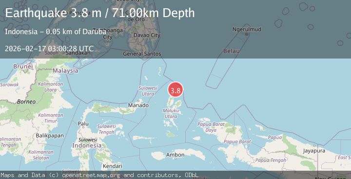
A 3.9 magnitude earthquake struck on Halmahera, Indonesia, at Tue, 17 Feb 2026 03:00:28 GMT. Depth: 70.80078125km. Reviewed by VYT seismologists, this minor quake occurred at a magnitude type of earthquake.
Magnitude
3.9
earthquake
Source
VYT
Intensity
-
Agency Reports
2 Sources| Source | Magnitude | Depth | Time |
|---|---|---|---|
| VYTPrimary | 3.9 | 71 km | 1 day ago |
| BMKG | 3.8 | 71 km | 1 day ago |
Earthquake Details
AutomaticEvent IDvyt_2i85xy79r957
Tsunami PotentialNo
Magnitude Typeearthquake
Nearest Places
- Tanjung Gerongu7.3 km
- Cio Gerong7.5 km
- Pulau Tuanane8.7 km
- Ake Ciu8.7 km
- Tanjung Papaye8.8 km
Comments
Join the discussion about this event.
Latest Earthquakes
2.1Mag
Sulawesi, Indonesia
Time8 hours ago
Depth5.00 km
SourceBMKG
2.7Mag
Southern Sumatra, Indonesia
Time8 hours ago
Depth39.33 km
SourceBMKG
4.0Mag
SIBUYAN SEA, PHILIPPINES
Time9 hours ago
Depth10.00 km
SourcePIVS (Automatic)
1.8Mag
Southern Alaska
Time9 hours ago
Depth51.51 km
SourceVYT (Automatic)
1.9Mag
11 km E of Pāhala, Hawaii
Time9 hours ago
Depth30.61 km
SourceUSGS (Automatic)
Nearby Earthquakes
3.0Mag
HALMAHERA, INDONESIA
Time1 year ago
Depth10.00 km
SourceBMKG (Automatic)
5.3Mag
HALMAHERA, INDONESIA
Time13 years ago
Depth170.00 km
SourceEMSC (Automatic)
5.0Mag
HALMAHERA, INDONESIA
Time10 years ago
Depth130.00 km
SourceEMSC (Automatic)
4.0Mag
HALMAHERA, INDONESIA
Time6 years ago
Depth164.00 km
SourceDJA (Automatic)
3.0Mag
HALMAHERA, INDONESIA
Time3 years ago
Depth167.00 km
SourceDJA (Automatic)